
East of England topographic map
Interactive map
Click on the map to display elevation.
About this map
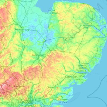
Name: East of England topographic map, elevation, terrain.
Location: East of England, England, United Kingdom (51.44828 -0.74579 52.99164 1.76891)
Average elevation: 39 m
Minimum elevation: -5 m
Maximum elevation: 267 m
The East of England region has the lowest elevation range in the UK. Twenty percent of the region is below mean sea level, most of this in North Cambridgeshire, Norfolk and on the Essex Coast. Most of the remaining area is of low elevation, with extensive glacial deposits. The Fens, a large area of reclaimed marshland, are mostly in North Cambridgeshire. The Fens include the lowest point in the country in the village of Holme: 2.75 metres (9.0 ft) below mean sea level. This area formerly included the body of open water known as Whittlesey Mere. The highest point in the region is at Clipper Down at 817 ft (249 m) above mean sea level, in the far southwestern corner of the region in the Ivinghoe Hills.
Other topographic maps
Click on a map to view its topography, its elevation and its terrain.
London
United Kingdom > England > London
London, Greater London, England, SW1A 2DX, United Kingdom
Average elevation: 42 m
Bristol
United Kingdom > England > City of Bristol
Bristol, City of Bristol, West of England, England, United Kingdom
Average elevation: 55 m
London
London, Greater London, England, United Kingdom
Average elevation: 66 m
Greater Manchester
Greater Manchester, England, United Kingdom
Average elevation: 141 m
Liverpool
Liverpool, Liverpool City Region, England, United Kingdom
Average elevation: 26 m
Newcastle upon Tyne
Newcastle upon Tyne, North of Tyne, England, United Kingdom
Average elevation: 57 m
Lake District National Park
Lake District National Park, England, United Kingdom
Average elevation: 206 m
Brighton
United Kingdom > England > Brighton and Hove
Brighton, Brighton and Hove, England, United Kingdom
Average elevation: 64 m
Greater London
Greater London, England, United Kingdom
Average elevation: 66 m
Northamptonshire
Northamptonshire, England, United Kingdom
Average elevation: 97 m
Coventry
Coventry, West Midlands Combined Authority, England, United Kingdom
Average elevation: 99 m
Castleton
United Kingdom > England > Derbyshire > High Peak
Castleton, High Peak, Derbyshire, England, United Kingdom
Average elevation: 326 m
South East England
South East England, England, United Kingdom
Average elevation: 69 m
West Midlands
United Kingdom > England > Warwickshire
West Midlands, Warwickshire, West Midlands Combined Authority, England, United Kingdom
Average elevation: 113 m
Kingston upon Thames
Kingston upon Thames, Greater London, England, KT1 1JS, United Kingdom
Average elevation: 19 m
Hull
United Kingdom > England > Kingston upon Hull
Hull, Kingston upon Hull, England, HU1 3RJ, United Kingdom
Average elevation: 21 m
Eastbourne
United Kingdom > England > East Sussex
Eastbourne, East Sussex, England, United Kingdom
Average elevation: 36 m
Corby
United Kingdom > England > North Northamptonshire > Corby
Corby, North Northamptonshire, East Midlands, England, United Kingdom
Average elevation: 98 m
Sheffield
Sheffield, South Yorkshire, England, United Kingdom
Average elevation: 168 m
Cold Higham
United Kingdom > England > West Northamptonshire
Cold Higham, West Northamptonshire, England, United Kingdom
Average elevation: 131 m
Kent
United Kingdom > England > Sevenoaks
Kent, Beechenlea Lane, Swanley, Sevenoaks, Kent, South East, England, BR8 7PR, United Kingdom
Average elevation: 37 m
Lincolnshire
Lincolnshire, East Midlands, England, United Kingdom
Average elevation: 28 m
Leicestershire
Leicestershire, East Midlands, England, United Kingdom
Average elevation: 97 m
Dorking
United Kingdom > England > Surrey > Mole Valley
Dorking, Mole Valley, Surrey, England, United Kingdom
Average elevation: 80 m
Cambridge
United Kingdom > England > Cambridge
Cambridge, Cambridgeshire, East of England, England, United Kingdom
Average elevation: 18 m
East Riding of Yorkshire
East Riding of Yorkshire, England, United Kingdom
Average elevation: 30 m
Newark on Trent
United Kingdom > England > Nottinghamshire > Newark and Sherwood
Newark on Trent, Newark and Sherwood, Nottinghamshire, England, NG24 1EJ, United Kingdom
Average elevation: 18 m
Skipton
United Kingdom > England > Skipton
Skipton, North Yorkshire, Yorkshire and the Humber, England, BD23 1DU, United Kingdom
Average elevation: 201 m
Enfield
United Kingdom > England > London
Enfield, Greater London, England, EN2 6LD, United Kingdom
Average elevation: 39 m
Lancaster
United Kingdom > England > Lancashire
Lancaster, Lancashire, England, United Kingdom
Average elevation: 84 m
Barrow-in-Furness
United Kingdom > England > Westmorland and Furness > Stank
Barrow-in-Furness, Stank, Westmorland and Furness, England, United Kingdom
Average elevation: 22 m
St Albans
United Kingdom > England > Hertfordshire > St Albans
St Albans, Hertfordshire, East of England, England, United Kingdom
Average elevation: 100 m
Birmingham
Birmingham, West Midlands Combined Authority, England, United Kingdom
Average elevation: 138 m
Swindon
United Kingdom > England > Swindon
Swindon, England, SN1 1LF, United Kingdom
Average elevation: 108 m
Peterborough
United Kingdom > England > City of Peterborough
Peterborough, City of Peterborough, Cambridgeshire and Peterborough, England, PE1 1XH, United Kingdom
Average elevation: 17 m
Durham
United Kingdom > England > County Durham
Durham, County Durham, North East, England, DH1 3NG, United Kingdom
Average elevation: 119 m
North Norfolk
United Kingdom > England > Norfolk
North Norfolk, Norfolk, England, United Kingdom
Average elevation: 26 m