
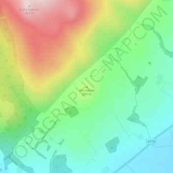
Drumbuie topographic map
Interactive map
Click on the map to display elevation.
About this map
Name: Drumbuie topographic map, elevation, terrain.
Average elevation: 176 m
Minimum elevation: 27 m
Maximum elevation: 432 m
Other topographic maps
Click on a map to view its topography, its elevation and its terrain.
Inverkeithing
United Kingdom > Scotland > Fife
Topographically, Inverkeithing is situated on a raised terrace sloping down towards Inverkeithing Bay, which cuts in to the south of the town, separating it from the North Queensferry peninsula. There are views from the town centre across the Firth of Forth to Edinburgh, Arthur's Seat, and the Pentland Hills.
Average elevation: 28 m
Skye
United Kingdom > Scotland > Highland
Beyond Loch Snizort to the west of Trotternish is the Waternish peninsula, which ends in Ardmore Point's double rock arch. Duirinish peninsula is separated from Waternish by Loch Dunvegan, which contains the island of Isay. It is ringed by sea cliffs that reach 296 metres (971 feet) on the west at Waterstein…
Average elevation: 63 m
Castlehill Reservoir
United Kingdom > Scotland > Perth and Kinross > Glendevon
Average elevation: 268 m
Isle of Arran
United Kingdom > Scotland > North Ayrshire
The island has three endemic species of tree, the Arran whitebeams. These trees are the Scottish or Arran whitebeam (Sorbus arranensis), the bastard mountain ash or cut-leaved whitebeam (Sorbus pseudofennica) and the Catacol whitebeam (Sorbus pseudomeinichii). If rarity is measured by numbers alone they are…
Average elevation: 98 m
Cumbernauld
United Kingdom > Scotland > North Lanarkshire
Cumbernauld's name probably comes from the Gaelic comar nan allt, meaning "meeting of the burns or streams". There are differing views as to the etymology of this. One theory is that from its high point in the Central Belt, its streams flow both west to the River Clyde and east to the Firth of Forth so…
Average elevation: 113 m
Orkney Islands
United Kingdom > Scotland > Orkney Islands
The southern group of islands surrounds Scapa Flow. Hoy is the second largest of the Orkney Isles and Ward Hill at its northern end is the highest elevation in the archipelago. The Old Man of Hoy is a well-known seastack. Burray lies to the east of Scapa Flow and is linked by causeway to South Ronaldsay, which…
Average elevation: 9 m