Geolocate

Upper Harbour topographic map

Interactive map

Click on the map to display elevation.

About this map

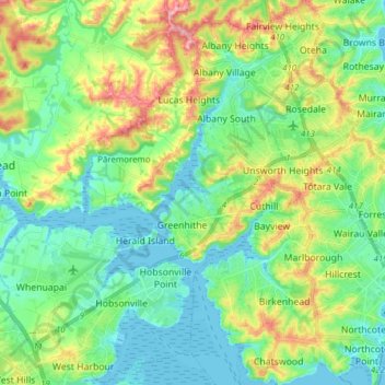
Name: Upper Harbour topographic map, elevation, terrain.

Location: Upper Harbour, Auckland, New Zealand (-36.82564 174.59115 -36.70247 174.74231)

Average elevation: 42 m

Minimum elevation: 0 m

Maximum elevation: 138 m

Other topographic maps

Click on a map to view its topography, its elevation and its terrain.

Pukekohe

New Zealand > Auckland > Franklin

Average elevation: 78 m

Waiwera

New Zealand > Auckland > Hibiscus and Bays

Average elevation: 23 m

Huapai

New Zealand > Auckland > Rodney

Average elevation: 52 m

Shelly Beach

New Zealand > Auckland > Rodney

Average elevation: 8 m

Waiuku

New Zealand > Auckland > Franklin

Average elevation: 32 m

Pākiri

New Zealand > Auckland > Rodney

Average elevation: 80 m

Ōtara

New Zealand > Auckland > Ōtara-Papatoetoe

Average elevation: 15 m

Matakana River

New Zealand > Auckland > Rodney > Matakana

Average elevation: 26 m

Bastion Point

New Zealand > Auckland > Ōrākei

Average elevation: 11 m

Mount Eden

New Zealand > Auckland > Albert-Eden

Average elevation: 81 m

Marivare Reserve

New Zealand > Auckland > Albert-Eden

Average elevation: 90 m

Clevedon

New Zealand > Auckland > Franklin

Average elevation: 37 m

Cox's Creek

New Zealand > Auckland > Waitemata

Average elevation: 25 m

Tryphena

New Zealand > Auckland > Aotea Great Barrier > Tryphena

Average elevation: 93 m

North Shore

New Zealand > Auckland > Kaipātiki

Average elevation: 57 m

Glenbrook

New Zealand > Auckland > Franklin

Average elevation: 51 m

Warkworth

New Zealand > Auckland > Rodney

Average elevation: 61 m