
Make a donation
Gear up for your next adventure:
As an Amazon Associate, this site earns from qualifying purchases at no extra cost to you.
Sestriere topographic map
Click on the map to display elevation.
Make a donation
Gear up for your next adventure:
As an Amazon Associate, this site earns from qualifying purchases at no extra cost to you.
Sestriere
An elite track and field athletics meeting was held annually in Sestriere from 1988 to 1996, and again in 2004. The advantage of its high altitude in sprinting and jumping events held out hope of world records, with sponsor Ferrari offering a car as a bonus. One record was set, in the men's pole vault by Sergey Bubka in 1994; the men's and women's records in long jump were also beaten, but wind assisted.
Make a donation
Gear up for your next adventure:
As an Amazon Associate, this site earns from qualifying purchases at no extra cost to you.
About this map
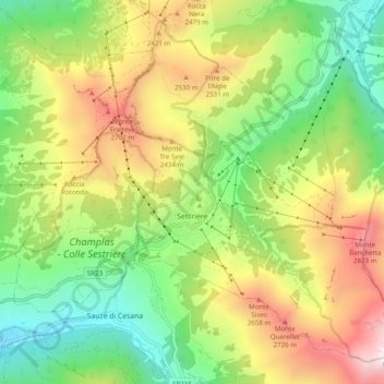
Name: Sestriere topographic map, elevation, terrain.
Location: Sestriere, Torino, Piedmont, 10058, Italy (44.93200 6.83315 44.99330 6.93098)
Average elevation: 2,120 m
Minimum elevation: 1,450 m
Maximum elevation: 3,099 m
Make a donation
Gear up for your next adventure:
As an Amazon Associate, this site earns from qualifying purchases at no extra cost to you.
Other topographic maps
Click on a map to view its topography, its elevation and its terrain.