Geolocate

Mount Morgan topographic map

Click on the map to display elevation.

About this map

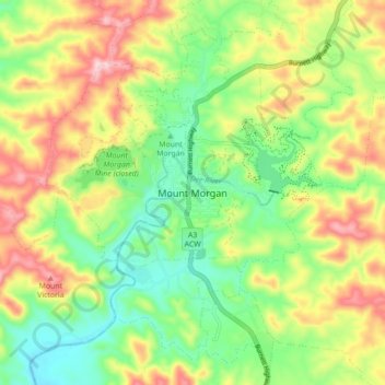
Name: Mount Morgan topographic map, elevation, terrain.

Location: Mount Morgan, Queensland, Australia (-23.68514 150.34831 -23.60514 150.42831)

Average elevation: 300 m

Minimum elevation: 186 m

Maximum elevation: 460 m

Queensland trails, hiking, mountain biking, running and outdoor activities

Other topographic maps

Click on a map to view its topography, its elevation and its terrain.

Walterhall

Australia > Queensland > Mount Morgan

Average elevation: 290 m

Mount Morgan

Australia > Queensland > Mount Morgan

Average elevation: 283 m

Gear up for your next adventure:

🎽Base Layers - Thermal base layers
🧢Outdoor Sun Hats - Sun protection hats for hiking
🎽Hiking Clothing - Breathable clothing for hiking
🦯Adjustable Trekking Poles - Reduce impact on knees when descending steep topographic ridges
🧭Global Orienteering Compass - High-precision liquid-filled compasses for accurate map reading and navigation

As an Amazon Associate, this site earns from qualifying purchases at no extra cost to you.