
Tewantin topographic map
Interactive map
Click on the map to display elevation.
About this map
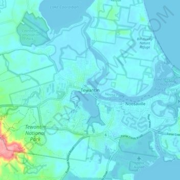
Name: Tewantin topographic map, elevation, terrain.
Location: Tewantin, Noosa Shire, Queensland, 4566, Australia (-26.43201 152.99918 -26.35201 153.07918)
Average elevation: 11 m
Minimum elevation: -5 m
Maximum elevation: 126 m
Queensland trails, hiking, mountain biking, running and outdoor activities
Other topographic maps
Click on a map to view its topography, its elevation and its terrain.