
Make a donation
Gear up for your next adventure:
As an Amazon Associate, this site earns from qualifying purchases at no extra cost to you.
Fitzroy Island topographic map
Click on the map to display elevation.
Make a donation
Gear up for your next adventure:
As an Amazon Associate, this site earns from qualifying purchases at no extra cost to you.
About this map
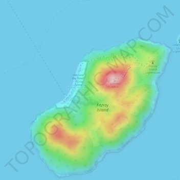
Name: Fitzroy Island topographic map, elevation, terrain.
Location: Fitzroy Island, Cairns, Queensland, Australia (-16.94028 145.98223 -16.92028 146.00223)
Average elevation: 34 m
Minimum elevation: -1 m
Maximum elevation: 235 m
Queensland trails, hiking, mountain biking, running and outdoor activities
Make a donation
Gear up for your next adventure:
As an Amazon Associate, this site earns from qualifying purchases at no extra cost to you.
Other topographic maps
Click on a map to view its topography, its elevation and its terrain.
Make a donation
Gear up for your next adventure:
As an Amazon Associate, this site earns from qualifying purchases at no extra cost to you.
Make a donation
Gear up for your next adventure:
As an Amazon Associate, this site earns from qualifying purchases at no extra cost to you.
Make a donation
Gear up for your next adventure:
As an Amazon Associate, this site earns from qualifying purchases at no extra cost to you.
Make a donation
Gear up for your next adventure:
As an Amazon Associate, this site earns from qualifying purchases at no extra cost to you.
Kanimbla
Australia > Queensland > Cairns
The suburb straddles the upper reaches of Moody's Creek and is bordered to the north by the Cairns Western Arterial Road (state route 91). The main road that goes through Kanimbla is Ramsey Drive. Along the middle of the northern boundary is Whites Gap. In the south west elevations reach heights greater than…
Average elevation: 121 m
Make a donation
Gear up for your next adventure:
As an Amazon Associate, this site earns from qualifying purchases at no extra cost to you.