
Make a donation
Gear up for your next adventure:
As an Amazon Associate, this site earns from qualifying purchases at no extra cost to you.
Deagon topographic map
Click on the map to display elevation.
Make a donation
Gear up for your next adventure:
As an Amazon Associate, this site earns from qualifying purchases at no extra cost to you.
Deagon
Deagon has a flat topography with one of its boundaries being Cabbage Tree Creek. The Creek's catchment is largely urbanised but the Boondall Wetlands, which is separated from Deagon by the Creek, plays an important role in providing essential habitat for a range of birds and animals, including migratory birds, which make their way from the arctic circle. The Boondall Wetlands near Deagon have ecosystems that are fresh as well as areas that are salt water. The smaller reserves such as Brighton and Deagon Wetlands are fresh water only. The Deagon Wetland is an important remnant of tea tree woodland on a 50ha site. Notable bird species include the striped honeyeater and the white-cheeked honeyeater.
Make a donation
Gear up for your next adventure:
As an Amazon Associate, this site earns from qualifying purchases at no extra cost to you.
About this map
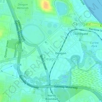
Name: Deagon topographic map, elevation, terrain.
Location: Deagon, City of Brisbane, Queensland, Australia (-27.33631 153.04574 -27.31949 153.07106)
Average elevation: 7 m
Minimum elevation: -1 m
Maximum elevation: 28 m
Queensland trails, hiking, mountain biking, running and outdoor activities
Make a donation
Gear up for your next adventure:
As an Amazon Associate, this site earns from qualifying purchases at no extra cost to you.
Other topographic maps
Click on a map to view its topography, its elevation and its terrain.
Make a donation
Gear up for your next adventure:
As an Amazon Associate, this site earns from qualifying purchases at no extra cost to you.
Make a donation
Gear up for your next adventure:
As an Amazon Associate, this site earns from qualifying purchases at no extra cost to you.
Make a donation
Gear up for your next adventure:
As an Amazon Associate, this site earns from qualifying purchases at no extra cost to you.