
Luapula Province topographic map
Interactive map
Click on the map to display elevation.
About this map
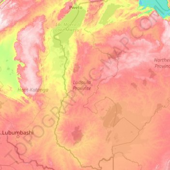
Name: Luapula Province topographic map, elevation, terrain.
Location: Luapula Province, Zambia (-12.46016 28.37111 -8.37930 30.46374)
Average elevation: 1,211 m
Minimum elevation: 764 m
Maximum elevation: 1,907 m
Other topographic maps
Click on a map to view its topography, its elevation and its terrain.
Chinsali
The geographical coordinates of Chinsali Town are 10°33'08.0"S, 32°04'09.0"E (Latitude:-10.552222; Longitude:32.069167). The town is nestled at an average elevation of 1,383 metres (4,537 ft) above mean sea level.
Average elevation: 1,294 m
Chipata
Chipata is located on the Great East Road, approximately 570 kilometres (354 mi) east of Lusaka, the capital city of Zambia. This is about 150 kilometres (93 mi) west of Lilongwe, the capital city of Malawi. The geographical coordinates of Chipata are 13°38′43.0″S, 32°38′47.0″E. The average elevation…
Average elevation: 1,133 m