Geolocate

Fortitude Valley topographic map

Click on the map to display elevation.

About this map

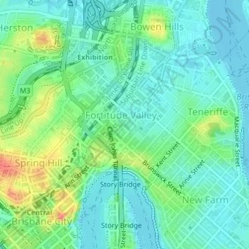
Name: Fortitude Valley topographic map, elevation, terrain.

Location: Fortitude Valley, City of Brisbane, Queensland, Australia (-27.46522 153.02740 -27.44937 153.04323)

Average elevation: 18 m

Minimum elevation: -2 m

Maximum elevation: 60 m

Queensland trails, hiking, mountain biking, running and outdoor activities

Other topographic maps

Click on a map to view its topography, its elevation and its terrain.

Bulimba Creek

Australia > Queensland > City of Brisbane

Average elevation: 11 m

Tangalooma

Australia > Queensland > City of Brisbane

Average elevation: 41 m

Enoggera Hill

Australia > Queensland > City of Brisbane

Average elevation: 114 m

Enoggera Dam

Australia > Queensland > City of Brisbane

Average elevation: 90 m

Tangalooma

Australia > Queensland > City of Brisbane

Average elevation: 41 m

Blunder Creek

Australia > Queensland > City of Brisbane

Average elevation: 26 m

Gear up for your next adventure:

🎧Bluetooth Outdoor Earbuds - Listen to navigation cues or podcasts during long solo treks
🪑Portable Backpacking Chairs - A comfortable seat for studying maps at the end of the day
🏕️Camping Gear - Essential camping equipment
🚴Bike GPS - GPS devices for cycling
💧Personal Water Filters - Drink safely from streams and lakes identified on your map

As an Amazon Associate, this site earns from qualifying purchases at no extra cost to you.