
Make a donation
Gear up for your next adventure:
As an Amazon Associate, this site earns from qualifying purchases at no extra cost to you.
Charnwood topographic map
Click on the map to display elevation.
Make a donation
Gear up for your next adventure:
As an Amazon Associate, this site earns from qualifying purchases at no extra cost to you.
About this map
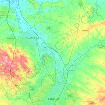
Name: Charnwood topographic map, elevation, terrain.
Location: Charnwood, Leicestershire, England, United Kingdom (52.65385 -1.33507 52.82470 -0.94725)
Average elevation: 92 m
Minimum elevation: 29 m
Maximum elevation: 269 m
Make a donation
Gear up for your next adventure:
As an Amazon Associate, this site earns from qualifying purchases at no extra cost to you.
Other topographic maps
Click on a map to view its topography, its elevation and its terrain.
Breedon on the Hill
United Kingdom > England > Leicestershire > North West Leicestershire
Average elevation: 84 m
Make a donation
Gear up for your next adventure:
As an Amazon Associate, this site earns from qualifying purchases at no extra cost to you.
Stretton Baskerville
United Kingdom > England > Leicestershire > Hinckley and Bosworth
Average elevation: 111 m
Make a donation
Gear up for your next adventure:
As an Amazon Associate, this site earns from qualifying purchases at no extra cost to you.
Coalville
United Kingdom > England > Leicestershire > North West Leicestershire
Average elevation: 149 m
Donington Le Heath
United Kingdom > England > Leicestershire > North West Leicestershire
Average elevation: 148 m
Make a donation
Gear up for your next adventure:
As an Amazon Associate, this site earns from qualifying purchases at no extra cost to you.
Lount Wood
United Kingdom > England > Leicestershire > North West Leicestershire > Lount
Average elevation: 131 m
Ellistown
United Kingdom > England > Leicestershire > North West Leicestershire
Average elevation: 153 m
Coalville
United Kingdom > England > Leicestershire > North West Leicestershire
Average elevation: 149 m
Make a donation
Gear up for your next adventure:
As an Amazon Associate, this site earns from qualifying purchases at no extra cost to you.
Albert Village
United Kingdom > England > Leicestershire > North West Leicestershire
Average elevation: 113 m
Oaks in Charnwood
United Kingdom > England > Leicestershire > North West Leicestershire
Average elevation: 155 m
Langham Brook
United Kingdom > England > Leicestershire > Melton > Saxby > Freeby
Average elevation: 94 m
Stretton Baskerville
United Kingdom > England > Leicestershire > Hinckley and Bosworth
Average elevation: 111 m
Make a donation
Gear up for your next adventure:
As an Amazon Associate, this site earns from qualifying purchases at no extra cost to you.
Beacon Hill Country Park
United Kingdom > England > Leicestershire > Charnwood > Woodhouse Eaves
Average elevation: 164 m
Saddington Reservoir
United Kingdom > England > Leicestershire > Harborough > Saddington
Average elevation: 128 m
Make a donation
Gear up for your next adventure:
As an Amazon Associate, this site earns from qualifying purchases at no extra cost to you.
Make a donation
Gear up for your next adventure:
As an Amazon Associate, this site earns from qualifying purchases at no extra cost to you.
Swithland Wood
United Kingdom > England > Leicestershire > Charnwood > Swithland
Average elevation: 107 m
Lockington
United Kingdom > England > Leicestershire > North West Leicestershire
Average elevation: 47 m
Make a donation
Gear up for your next adventure:
As an Amazon Associate, this site earns from qualifying purchases at no extra cost to you.
Make a donation
Gear up for your next adventure:
As an Amazon Associate, this site earns from qualifying purchases at no extra cost to you.
Ashby de la Zouch Canal
United Kingdom > England > Leicestershire > North West Leicestershire > Moira
Average elevation: 100 m
Make a donation
Gear up for your next adventure:
As an Amazon Associate, this site earns from qualifying purchases at no extra cost to you.
Bardon Hill
United Kingdom > England > Leicestershire > North West Leicestershire
Average elevation: 199 m
Make a donation
Gear up for your next adventure:
As an Amazon Associate, this site earns from qualifying purchases at no extra cost to you.
Make a donation
Gear up for your next adventure:
As an Amazon Associate, this site earns from qualifying purchases at no extra cost to you.
Adrian's Spinney
United Kingdom > England > Leicestershire > Harborough > Stoughton
Average elevation: 113 m
Make a donation
Gear up for your next adventure:
As an Amazon Associate, this site earns from qualifying purchases at no extra cost to you.
Kirkby Mallory
United Kingdom > England > Leicestershire > Hinckley and Bosworth
Average elevation: 115 m
Isley Walton
United Kingdom > England > Leicestershire > North West Leicestershire
Average elevation: 76 m
Make a donation
Gear up for your next adventure:
As an Amazon Associate, this site earns from qualifying purchases at no extra cost to you.
Thringstone
United Kingdom > England > Leicestershire > North West Leicestershire
Average elevation: 126 m
Make a donation
Gear up for your next adventure:
As an Amazon Associate, this site earns from qualifying purchases at no extra cost to you.
Brocks Hill
United Kingdom > England > Leicestershire > Oadby and Wigston > Oadby
Average elevation: 102 m
Hugglescote
United Kingdom > England > Leicestershire > North West Leicestershire
Average elevation: 154 m
Make a donation
Gear up for your next adventure:
As an Amazon Associate, this site earns from qualifying purchases at no extra cost to you.
Ratcliffe Culey
United Kingdom > England > Leicestershire > Hinckley and Bosworth
Average elevation: 77 m
Coalville
United Kingdom > England > Leicestershire > North West Leicestershire
Average elevation: 149 m
Make a donation
Gear up for your next adventure:
As an Amazon Associate, this site earns from qualifying purchases at no extra cost to you.
Coalville
United Kingdom > England > Leicestershire > North West Leicestershire
Average elevation: 148 m
Six Hills
United Kingdom > England > Leicestershire > Charnwood > Burton on the Wolds
Average elevation: 128 m
Make a donation
Gear up for your next adventure:
As an Amazon Associate, this site earns from qualifying purchases at no extra cost to you.
Kirkby Mallory
United Kingdom > England > Leicestershire > Hinckley and Bosworth
Average elevation: 115 m
Make a donation
Gear up for your next adventure:
As an Amazon Associate, this site earns from qualifying purchases at no extra cost to you.
Old John
United Kingdom > England > Leicestershire > Charnwood > Newtown Linford
Average elevation: 143 m
Make a donation
Gear up for your next adventure:
As an Amazon Associate, this site earns from qualifying purchases at no extra cost to you.
Diseworth
United Kingdom > England > Leicestershire > North West Leicestershire
Average elevation: 77 m
Watermead Country Park
United Kingdom > England > Leicestershire > Charnwood > Birstall
Average elevation: 59 m
Make a donation
Gear up for your next adventure:
As an Amazon Associate, this site earns from qualifying purchases at no extra cost to you.
Isley Walton
United Kingdom > England > Leicestershire > North West Leicestershire
Average elevation: 76 m
Make a donation
Gear up for your next adventure:
As an Amazon Associate, this site earns from qualifying purchases at no extra cost to you.
Make a donation
Gear up for your next adventure:
As an Amazon Associate, this site earns from qualifying purchases at no extra cost to you.
New Lubbesthorpe
United Kingdom > England > Leicestershire > Leicester Forest East
Average elevation: 95 m
Make a donation
Gear up for your next adventure:
As an Amazon Associate, this site earns from qualifying purchases at no extra cost to you.
Kegworth
United Kingdom > England > Leicestershire > North West Leicestershire
Average elevation: 47 m
Make a donation
Gear up for your next adventure:
As an Amazon Associate, this site earns from qualifying purchases at no extra cost to you.