
Agua Dulce topographic map
Interactive map
Click on the map to display elevation.
Agua Dulce
Agua Dulce (Spanish for "sweet water") is a census-designated place in Los Angeles County, California, United States. It lies at an elevation of 2,526 feet (770 m), northeast of Santa Clarita. The community had a population of 3,342 at the 2010 census and covers a geographic area of about 23 square miles (59 km2). The ZIP code is 91390 (shared with Green Valley and far northern Santa Clarita), and the area code is 661.
About this map
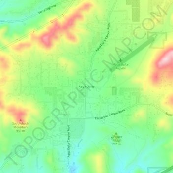
Name: Agua Dulce topographic map, elevation, terrain.
Location: Agua Dulce, California, United States (34.47638 -118.34563 34.51638 -118.30563)
Average elevation: 803 m
Minimum elevation: 694 m
Maximum elevation: 977 m