
Southend-on-Sea topographic map
Interactive map
Click on the map to display elevation.
About this map
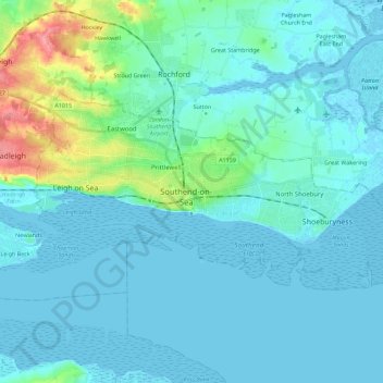
Name: Southend-on-Sea topographic map, elevation, terrain.
Location: Southend-on-Sea, Essex, England, United Kingdom (51.50447 0.62292 51.57680 0.84895)
Average elevation: 12 m
Minimum elevation: -3 m
Maximum elevation: 82 m
Other topographic maps
Click on a map to view its topography, its elevation and its terrain.
Passingford Bridge
United Kingdom > England > Essex > Epping Forest > Stapleford Tawney
Average elevation: 53 m
Gaunt's End
United Kingdom > England > Essex > Uttlesford > Molehill Green > Gaunt's End
Average elevation: 103 m