
Make a donation
Gear up for your next adventure:
As an Amazon Associate, this site earns from qualifying purchases at no extra cost to you.
Chagulak Island topographic map
Click on the map to display elevation.
Make a donation
Gear up for your next adventure:
As an Amazon Associate, this site earns from qualifying purchases at no extra cost to you.
Chagulak Island
Chagulak Island (also spelled Chugul, Chugula, Chegoula, or Tchougoulok; Russian: Чагулак) is a small, uninhabited volcanic island in the Islands of Four Mountains group in the Aleutian Islands of southwestern Alaska, United States. The 1.9 mi (3.1 km)-wide island consists of a single cone that reaches an elevation of 3,747 ft (1,142 m). Chagulak is a stratovolcano and is separated from the nearby Amukta Island by a channel about 4.3 miles (6.9 km) wide; though the two islands are joined underwater. No eruptions have been recorded and very little is known about the volcano, as the only study done on Chagulak so far is a single chemical analysis of a "low-potassium, high-alumina basaltic andesite" from the north shore.
Make a donation
Gear up for your next adventure:
As an Amazon Associate, this site earns from qualifying purchases at no extra cost to you.
About this map
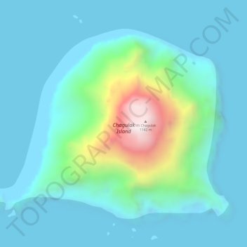
Name: Chagulak Island topographic map, elevation, terrain.
Average elevation: 160 m
Minimum elevation: -4 m
Maximum elevation: 1,018 m
Make a donation
Gear up for your next adventure:
As an Amazon Associate, this site earns from qualifying purchases at no extra cost to you.
Other topographic maps
Click on a map to view its topography, its elevation and its terrain.
Carlisle Island
United States > Alaska > Aleutians West Census Area
Despite its modest summit elevation, a small glacier exists high on the western slopes just below the rim of the summit crater.
Average elevation: 217 m
Make a donation
Gear up for your next adventure:
As an Amazon Associate, this site earns from qualifying purchases at no extra cost to you.