
Make a donation
Gear up for your next adventure:
As an Amazon Associate, this site earns from qualifying purchases at no extra cost to you.
Bavaria topographic map
Click on the map to display elevation.
Make a donation
Gear up for your next adventure:
As an Amazon Associate, this site earns from qualifying purchases at no extra cost to you.
About this map
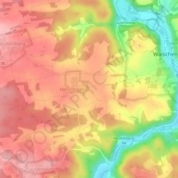
Name: Bavaria topographic map, elevation, terrain.
Location: Bavaria, 91344, Germany (49.79969 11.25670 49.88290 11.40963)
Average elevation: 432 m
Minimum elevation: 305 m
Maximum elevation: 580 m
Make a donation
Gear up for your next adventure:
As an Amazon Associate, this site earns from qualifying purchases at no extra cost to you.
Other topographic maps
Click on a map to view its topography, its elevation and its terrain.
Berlin
Berlin straddles the banks of the River Spree, which flows into the River Havel (a tributary of the River Elbe) in the western borough of Spandau. Among the city's main topographical features are the many lakes in the western and southeastern boroughs formed by the Spree, Havel, and Dahme rivers (the largest…
Average elevation: 47 m
Make a donation
Gear up for your next adventure:
As an Amazon Associate, this site earns from qualifying purchases at no extra cost to you.
Battle of the Seelow Heights
Germany > Brandenburg > Märkisch-Oderland > Seelow
Average elevation: 22 m
Hintersee
Germany > Bavaria > Landkreis Berchtesgadener Land > Ramsau bei Berchtesgaden
Average elevation: 1,005 m
Fleesensee
Germany > Mecklenburg-Vorpommern > Mecklenburgische Seenplatte > Göhren-Lebbin
Fleesensee is a lake in the Mecklenburgische Seenplatte district in Mecklenburg-Vorpommern, Germany. At an elevation of 62 metres (203 ft), its surface area is 10.78 square kilometres (4.16 sq mi).
Average elevation: 65 m
Hamburg
The neighborhoods of Neuenfelde, Cranz, Francop and Finkenwerder are part of the Altes Land (old land) region, the largest contiguous fruit-producing region in Central Europe. Neugraben-Fischbek has Hamburg's highest elevation, the Hasselbrack at 116.2 metres (381 ft) AMSL. Hamburg borders the states of…
Average elevation: 23 m
Make a donation
Gear up for your next adventure:
As an Amazon Associate, this site earns from qualifying purchases at no extra cost to you.
Brocken
Germany > Saxony-Anhalt > Landkreis Harz > Wernigerode
The Brocken, also sometimes referred to as the Blocksberg, is the highest peak in the Harz mountain range and also the highest peak in Northern Germany; it is near Schierke in the German state of Saxony-Anhalt between the rivers Weser and Elbe. Although its elevation of 1,141 metres (3,743 ft) is below alpine…
Average elevation: 963 m
Make a donation
Gear up for your next adventure:
As an Amazon Associate, this site earns from qualifying purchases at no extra cost to you.
Kessin
Germany > Mecklenburg-Vorpommern > Mecklenburgische Seenplatte > Grapzow
Average elevation: 30 m
Make a donation
Gear up for your next adventure:
As an Amazon Associate, this site earns from qualifying purchases at no extra cost to you.
Topograph
Germany > Saxony > Sächsische Schweiz-Osterzgebirge > Rosenthal-Bielatal
Average elevation: 385 m
Make a donation
Gear up for your next adventure:
As an Amazon Associate, this site earns from qualifying purchases at no extra cost to you.
Make a donation
Gear up for your next adventure:
As an Amazon Associate, this site earns from qualifying purchases at no extra cost to you.
Make a donation
Gear up for your next adventure:
As an Amazon Associate, this site earns from qualifying purchases at no extra cost to you.
Make a donation
Gear up for your next adventure:
As an Amazon Associate, this site earns from qualifying purchases at no extra cost to you.
Make a donation
Gear up for your next adventure:
As an Amazon Associate, this site earns from qualifying purchases at no extra cost to you.
Cape Arkona
Germany > Mecklenburg-Vorpommern > Vorpommern-Rügen > Vitt > Kap Arkona
Average elevation: 7 m
Rhön
The High Rhön (German: Hohe Rhön or Hochrhön) is that part of the central Rhön that lies in Hesse, Bavaria, and to a lesser extent in Thuringia; it covers an area of 344 km2 (132.8 sq mi) Landscape fact files by the BfN (c.f. section on Natural region division) and is up to 950.0 m (3,117 ft) and whose…
Average elevation: 409 m
Make a donation
Gear up for your next adventure:
As an Amazon Associate, this site earns from qualifying purchases at no extra cost to you.
Soiernsee
Germany > Bavaria > Landkreis Garmisch-Partenkirchen > Mittenwald
Average elevation: 1,766 m
Hundestrand Brasilien
Germany > Schleswig-Holstein > Plön > Schönberg (Holstein) > Schönberger Strand > Brasilien
Average elevation: 0 m
Make a donation
Gear up for your next adventure:
As an Amazon Associate, this site earns from qualifying purchases at no extra cost to you.
Teufelsmoor
Germany > Mecklenburg-Vorpommern > Ludwigslust-Parchim > Sternberg
Average elevation: 43 m
Börninghausen
Germany > North Rhine-Westphalia > Kreis Minden-Lübbecke > Preußisch Oldendorf
Average elevation: 135 m
Make a donation
Gear up for your next adventure:
As an Amazon Associate, this site earns from qualifying purchases at no extra cost to you.
Make a donation
Gear up for your next adventure:
As an Amazon Associate, this site earns from qualifying purchases at no extra cost to you.
Oberried
Germany > Baden-Württemberg > Landkreis Breisgau-Hochschwarzwald
The Schauinsland (literally "look-into-the-country"; near Freiburg im Breisgau, Germany) is a mountain in the Black Forest with an elevation of 1,284 m (4,213 ft) above sea level. It is a popular destination for day trips. Due to the high amount of silver mining, it was previously known as "Erzkasten"…
Average elevation: 1,068 m
Make a donation
Gear up for your next adventure:
As an Amazon Associate, this site earns from qualifying purchases at no extra cost to you.
Langballigau
Germany > Schleswig-Holstein > Schleswig-Flensburg > Langballigholz
Average elevation: 12 m
Leimersdorf
Germany > Rhineland-Palatinate > Landkreis Ahrweiler > Grafschaft
Average elevation: 204 m
Make a donation
Gear up for your next adventure:
As an Amazon Associate, this site earns from qualifying purchases at no extra cost to you.
Make a donation
Gear up for your next adventure:
As an Amazon Associate, this site earns from qualifying purchases at no extra cost to you.
Zimmet
Germany > Rhineland-Palatinate > Landkreis Bernkastel-Wittlich > Piesport
Average elevation: 185 m
Make a donation
Gear up for your next adventure:
As an Amazon Associate, this site earns from qualifying purchases at no extra cost to you.
Schulenberg
Germany > North Rhine – Westphalia > Ennepe-Ruhr-Kreis > Hattingen
Average elevation: 130 m
Make a donation
Gear up for your next adventure:
As an Amazon Associate, this site earns from qualifying purchases at no extra cost to you.
Dusseldorf
Germany > North Rhine-Westphalia
The Archbishop of Cologne's forces were wiped out by the forces of the count of Berg who were supported by citizens and farmers of Cologne and Düsseldorf, paving the way for Düsseldorf's elevation to city status, which is commemorated today by a monument on the Burgplatz. The custom of turning cartwheels is…
Average elevation: 63 m
Make a donation
Gear up for your next adventure:
As an Amazon Associate, this site earns from qualifying purchases at no extra cost to you.
Make a donation
Gear up for your next adventure:
As an Amazon Associate, this site earns from qualifying purchases at no extra cost to you.
Make a donation
Gear up for your next adventure:
As an Amazon Associate, this site earns from qualifying purchases at no extra cost to you.
Struberg
Germany > North Rhine-Westphalia > Kreis Minden-Lübbecke > Hüllhorst
Average elevation: 191 m
Burg Hohlenfels
Germany > Rhineland-Palatinate > Rhein-Lahn-Kreis > Mudershausen
Average elevation: 282 m
Untersalzberg I
Germany > Bavaria > Landkreis Berchtesgadener Land > Berchtesgaden
Average elevation: 758 m
Make a donation
Gear up for your next adventure:
As an Amazon Associate, this site earns from qualifying purchases at no extra cost to you.
Make a donation
Gear up for your next adventure:
As an Amazon Associate, this site earns from qualifying purchases at no extra cost to you.
Hamburg
The neighborhoods of Neuenfelde, Cranz, Francop and Finkenwerder are part of the Altes Land (old land) region, the largest contiguous fruit-producing region in Central Europe. Neugraben-Fischbek has Hamburg's highest elevation, the Hasselbrack at 116.2 metres (381 ft) AMSL. Hamburg borders the states of…
Average elevation: 56 m
Lüderich
Germany > North Rhine-Westphalia > Rheinisch-Bergischer Kreis > Rösrath
Average elevation: 168 m
Make a donation
Gear up for your next adventure:
As an Amazon Associate, this site earns from qualifying purchases at no extra cost to you.
Make a donation
Gear up for your next adventure:
As an Amazon Associate, this site earns from qualifying purchases at no extra cost to you.