
Make a donation
Gear up for your next adventure:
As an Amazon Associate, this site earns from qualifying purchases at no extra cost to you.
Karlsruhe topographic map
Click on the map to display elevation.
Make a donation
Gear up for your next adventure:
As an Amazon Associate, this site earns from qualifying purchases at no extra cost to you.
About this map
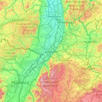
Name: Karlsruhe topographic map, elevation, terrain.
Location: Karlsruhe, Baden-Württemberg, 76137, Germany (48.31060 7.70407 49.71060 9.10407)
Average elevation: 316 m
Minimum elevation: 84 m
Maximum elevation: 1,161 m
Make a donation
Gear up for your next adventure:
As an Amazon Associate, this site earns from qualifying purchases at no extra cost to you.
Other topographic maps
Click on a map to view its topography, its elevation and its terrain.
Müllheim
Germany > Baden-Württemberg > Landkreis Breisgau-Hochschwarzwald > Müllheim im Markgräflerland
Average elevation: 268 m
Make a donation
Gear up for your next adventure:
As an Amazon Associate, this site earns from qualifying purchases at no extra cost to you.
Make a donation
Gear up for your next adventure:
As an Amazon Associate, this site earns from qualifying purchases at no extra cost to you.
Make a donation
Gear up for your next adventure:
As an Amazon Associate, this site earns from qualifying purchases at no extra cost to you.
Neuenburg am Rhein
Germany > Baden-Württemberg > Landkreis Breisgau-Hochschwarzwald
Average elevation: 255 m
73061
Germany > Baden-Württemberg > Landkreis Göppingen > Ebersbach an der Fils
Average elevation: 328 m
Make a donation
Gear up for your next adventure:
As an Amazon Associate, this site earns from qualifying purchases at no extra cost to you.
78239
Germany > Baden-Württemberg > Landkreis Konstanz > Rielasingen-Worblingen
Average elevation: 427 m
Make a donation
Gear up for your next adventure:
As an Amazon Associate, this site earns from qualifying purchases at no extra cost to you.
Oberesslingen
Germany > Baden-Württemberg > Landkreis Esslingen > Esslingen am Neckar
Average elevation: 279 m
Make a donation
Gear up for your next adventure:
As an Amazon Associate, this site earns from qualifying purchases at no extra cost to you.
Make a donation
Gear up for your next adventure:
As an Amazon Associate, this site earns from qualifying purchases at no extra cost to you.
Make a donation
Gear up for your next adventure:
As an Amazon Associate, this site earns from qualifying purchases at no extra cost to you.
Make a donation
Gear up for your next adventure:
As an Amazon Associate, this site earns from qualifying purchases at no extra cost to you.
Eberbach
Germany > Baden-Württemberg > Rhein-Neckar-Kreis
Eberbach lies at the foot of the Katzenbuckel, at 626 m the highest elevation in the Odenwald, in the Naturpark Neckartal-Odenwald, on the romantic Burgenstraße (Castle Road) along the river Neckar.
Average elevation: 372 m
Dittishausen
Germany > Baden-Württemberg > Landkreis Breisgau-Hochschwarzwald > Löffingen
Average elevation: 816 m
Make a donation
Gear up for your next adventure:
As an Amazon Associate, this site earns from qualifying purchases at no extra cost to you.
Make a donation
Gear up for your next adventure:
As an Amazon Associate, this site earns from qualifying purchases at no extra cost to you.
Make a donation
Gear up for your next adventure:
As an Amazon Associate, this site earns from qualifying purchases at no extra cost to you.
Alfdorf
Germany > Baden-Württemberg > Rems-Murr-Kreis
The municipality (Gemeinde) of Alfdorf lies at the easternmost extremity of the Rems-Murr district, along its border with the Ostalb district. Alfdorf is physically located in the Schurwald and Welzheim Forest, regions of the larger Swabian-Franconian Forest. Elevation above sea level in the municipal area…
Average elevation: 476 m
Make a donation
Gear up for your next adventure:
As an Amazon Associate, this site earns from qualifying purchases at no extra cost to you.
Make a donation
Gear up for your next adventure:
As an Amazon Associate, this site earns from qualifying purchases at no extra cost to you.
Make a donation
Gear up for your next adventure:
As an Amazon Associate, this site earns from qualifying purchases at no extra cost to you.
Make a donation
Gear up for your next adventure:
As an Amazon Associate, this site earns from qualifying purchases at no extra cost to you.
Make a donation
Gear up for your next adventure:
As an Amazon Associate, this site earns from qualifying purchases at no extra cost to you.
Make a donation
Gear up for your next adventure:
As an Amazon Associate, this site earns from qualifying purchases at no extra cost to you.
Holzgerlingen
Germany > Baden-Württemberg > Landkreis Böblingen > Holzgerlingen
Average elevation: 485 m
Feldberg
Germany > Baden-Württemberg > Landkreis Breisgau-Hochschwarzwald
Feldberg is a municipality in the district of Breisgau-Hochschwarzwald in Baden-Württemberg in southern Germany. It is located near the Feldberg, the highest summit in Baden-Württemberg. It comprises the settlements of Altglashütten, Neuglashütten, Falkau, Bärental, and Feldberg. At an elevation of 1,277…
Average elevation: 1,071 m
Make a donation
Gear up for your next adventure:
As an Amazon Associate, this site earns from qualifying purchases at no extra cost to you.
Make a donation
Gear up for your next adventure:
As an Amazon Associate, this site earns from qualifying purchases at no extra cost to you.
Wendlingen am Neckar
Germany > Baden-Württemberg > Landkreis Esslingen > Wendlingen am Neckar
Average elevation: 295 m
Make a donation
Gear up for your next adventure:
As an Amazon Associate, this site earns from qualifying purchases at no extra cost to you.
Büsingen am Hochrhein
Germany > Baden-Württemberg > Landkreis Konstanz > Büsingen am Hochrhein
Average elevation: 426 m
Nippenburg
Germany > Baden-Württemberg > Landkreis Ludwigsburg > Schwieberdingen > Nippenburg
Average elevation: 308 m
Make a donation
Gear up for your next adventure:
As an Amazon Associate, this site earns from qualifying purchases at no extra cost to you.
Tauberbischofsheim
Germany > Baden-Württemberg > Main-Tauber-Kreis > Tauberbischofsheim
Average elevation: 289 m
Vaihingen an der Enz
Germany > Baden-Württemberg > Landkreis Ludwigsburg > Vaihingen an der Enz
At the top of the town is since 1256 the mayor and the court, consisting of twelve citizens, including four mayors. Chairman of the court was the official mayor. With the elevation to Große Kreisstadt on January 1, 1973, the mayor bears the official title Lord mayor. He is directly elected by the electorate…
Average elevation: 253 m
Lichtenstein
Germany > Baden-Württemberg > Landkreis Reutlingen
The municipality (Gemeinde) of Lichtenstein covers 34.24 square kilometres (13.22 sq mi) of the Reutlingen district, in the state of the Federal Republic of Germany. It is physically located in the middle of the Swabian Jura, on the edge of the Middle Kuppenalb [de] in the valley of the river Echaz. Elevation…
Average elevation: 689 m
Make a donation
Gear up for your next adventure:
As an Amazon Associate, this site earns from qualifying purchases at no extra cost to you.
Oberderdingen
Germany > Baden-Württemberg > Landkreis Karlsruhe > Oberderdingen
Average elevation: 225 m
Backnang
Germany > Baden-Württemberg > Rems-Murr-Kreis
Before 1930 the title for this position was Stadtschultheiß. In 1930 the title became Bürgermeister (Mayor), and in 1956 with the elevation of Backnang to a "large district town," the title was changed to Oberbürgermeister (Lord Mayor).
Average elevation: 303 m
Make a donation
Gear up for your next adventure:
As an Amazon Associate, this site earns from qualifying purchases at no extra cost to you.
Naturfreibad Sankt Märgen
Germany > Baden-Württemberg > Landkreis Breisgau-Hochschwarzwald > St. Märgen
Average elevation: 893 m
Furtwangen im Schwarzwald
Germany > Baden-Württemberg > Schwarzwald-Baar-Kreis
After the city elevation in 1873, industrialization began in Furtwangen through the watch industry. Large companies such as Baduf, Furtwängler and Siedle emerged. In total, they provided 2,000 jobs. At the turn of the century, the Furtwang industry was at its peak. The traffic conditions were improved by the…
Average elevation: 971 m
Hülben
Germany > Baden-Württemberg > Landkreis Reutlingen
The Hülben stalactite cave was discovered during the construction of national road Bad Urach-Hülben on September 19, 1978, it is a stalactite cave with stalactites and stalagmites. An about 5 m deep shaft leads into the easily accessible part of the cave. This has about room size, but with only partial low…
Average elevation: 667 m
Make a donation
Gear up for your next adventure:
As an Amazon Associate, this site earns from qualifying purchases at no extra cost to you.