
Make a donation
Gear up for your next adventure:
As an Amazon Associate, this site earns from qualifying purchases at no extra cost to you.
Baden-Baden topographic map
Click on the map to display elevation.
Make a donation
Gear up for your next adventure:
As an Amazon Associate, this site earns from qualifying purchases at no extra cost to you.
About this map
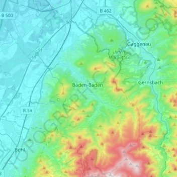
Name: Baden-Baden topographic map, elevation, terrain.
Location: Baden-Baden, Baden-Württemberg, Germany (48.66674 8.10778 48.84791 8.32095)
Average elevation: 289 m
Minimum elevation: 108 m
Maximum elevation: 1,001 m
Make a donation
Gear up for your next adventure:
As an Amazon Associate, this site earns from qualifying purchases at no extra cost to you.
Other topographic maps
Click on a map to view its topography, its elevation and its terrain.
Make a donation
Gear up for your next adventure:
As an Amazon Associate, this site earns from qualifying purchases at no extra cost to you.
Oberried
Germany > Baden-Württemberg > Landkreis Breisgau-Hochschwarzwald
The Schauinsland (literally "look-into-the-country"; near Freiburg im Breisgau, Germany) is a mountain in the Black Forest with an elevation of 1,284 m (4,213 ft) above sea level. It is a popular destination for day trips. Due to the high amount of silver mining, it was previously known as "Erzkasten"…
Average elevation: 1,068 m
Make a donation
Gear up for your next adventure:
As an Amazon Associate, this site earns from qualifying purchases at no extra cost to you.
Make a donation
Gear up for your next adventure:
As an Amazon Associate, this site earns from qualifying purchases at no extra cost to you.
Ravensburg
Germany > Baden-Württemberg > Landkreis Ravensburg > Ravensburg > Ravensburg
Average elevation: 508 m
Make a donation
Gear up for your next adventure:
As an Amazon Associate, this site earns from qualifying purchases at no extra cost to you.
Dagersheim
Germany > Baden-Württemberg > Landkreis Böblingen > Böblingen > Dagersheim
Average elevation: 448 m
Bergerhausen
Germany > Baden-Württemberg > Landkreis Biberach > Biberach an der Riß
Average elevation: 579 m
Make a donation
Gear up for your next adventure:
As an Amazon Associate, this site earns from qualifying purchases at no extra cost to you.
Östringen
Germany > Baden-Württemberg > Landkreis Karlsruhe > Östringen > Östringen
Average elevation: 177 m
Nippenburg
Germany > Baden-Württemberg > Landkreis Ludwigsburg > Schwieberdingen > Nippenburg
Average elevation: 308 m
Make a donation
Gear up for your next adventure:
As an Amazon Associate, this site earns from qualifying purchases at no extra cost to you.
Kleinengstingen
Germany > Baden-Württemberg > Landkreis Reutlingen > Kleinengstingen
Average elevation: 730 m
Kniebis
Germany > Baden-Württemberg > Landkreis Freudenstadt > Freudenstadt > Kniebis
Average elevation: 856 m
Engstingen
Germany > Baden-Württemberg > Landkreis Reutlingen
Engstingen is located on the northern edge of the Swabian Jura, at 680–750 metres (2,230–2,460 ft) altitude on the Alb plateau near the Alb edge in the valley of Ur-Lauter, about 15 km south of the town Reutlingen.
Average elevation: 738 m
Make a donation
Gear up for your next adventure:
As an Amazon Associate, this site earns from qualifying purchases at no extra cost to you.