
Örebro kommun topographic map
Interactive map
Click on the map to display elevation.
About this map
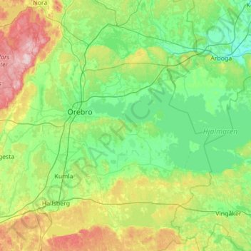
Name: Örebro kommun topographic map, elevation, terrain.
Location: Örebro kommun, Comté d'Örebro, Svealand, Suède (58.95652 14.76059 59.52375 15.79853)
Average elevation: 73 m
Minimum elevation: 4 m
Maximum elevation: 291 m
Other topographic maps
Click on a map to view its topography, its elevation and its terrain.
Brevens bruk
Suède > Comté d'Örebro > Brevens bruk
Brevens bruk, Örebro, Comté d'Örebro, Svealand, 715 96, Suède
Average elevation: 93 m
Lekeberg
Lekeberg, Landskapet Närke, Comté d'Örebro, Svealand, Suède
Average elevation: 103 m
Tivedens nationalpark
Suède > Comté d'Örebro > Tivedstorp
Tivedens nationalpark, Kojvägen, Tullsjöängen, Tived distrikt, Tivedstorp, Laxå, Comté d'Örebro, Götaland, 69597, Suède
Average elevation: 177 m