
Pune topographic map
Interactive map
Click on the map to display elevation.
About this map
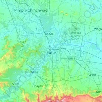
Name: Pune topographic map, elevation, terrain.
Location: Pune, Maharashtra, India (18.42950 73.74985 18.62087 74.02021)
Average elevation: 616 m
Minimum elevation: 529 m
Maximum elevation: 1,138 m
Pune lies on the western margin of the Deccan plateau, at an altitude of 560 m (1,840 ft) above sea level. It is on the leeward side of the Sahyadri mountain range, which forms a barrier from the Arabian Sea. It is a hilly city, with Vetal Hill rising to 800 m (2,600 ft) above sea level. The Sinhagad fort is at an altitude of 1,300 metres (4,300 feet).
Other topographic maps
Click on a map to view its topography, its elevation and its terrain.
Waruda
India > Maharashtra > Teosa
Waruda, Teosa, Amravati, Maharashtra, India
Average elevation: 335 m
Murud Akola
India > Maharashtra > Latur
Murud Akola, Latur, Maharashtra, 413511, India
Average elevation: 644 m
Purandar
India > Maharashtra > Purandhar
Purandar, Purandhar, Pune District, Maharashtra, 412302, India
Average elevation: 1,044 m
Pratapgad
India > Maharashtra > Arjuni Morgaon Taluka
Pratapgad, Arjuni Morgaon Taluka, Gondiya District, Maharashtra, India
Average elevation: 273 m
Bhor
India > Maharashtra > Bhor
Bhor, Pune District, Maharashtra, 412206, India
Average elevation: 650 m
Rajgad
India > Maharashtra > Mehkar
Rajgad, Mehkar, Buldhana District, Maharashtra, India
Average elevation: 512 m
Chowk
India > Maharashtra > Khalapur
Chowk, Khalapur, Raigad District, Maharashtra, India
Average elevation: 53 m
Belapur Fort
India > Maharashtra > Thane > Navi Mumbai
Belapur Fort, CIDCO Guest House Road, Belapur Village, Belapur West, Navi Mumbai, Thane, Maharashtra, 400706, India
Average elevation: 4 m
Warora
India > Maharashtra > Warora
Warora, Chandrapur, Maharashtra, 442907, India
Average elevation: 203 m
Berala
India > Maharashtra > Chikhli > Berala
Berala, Chikhli, Maharashtra, India
Average elevation: 645 m
Talai
India > Maharashtra > Dharni
Talai, Dharni, Amravati, Maharashtra, India
Average elevation: 323 m
Antop Hill
India > Maharashtra > Mumbai
Antop Hill, Mumbai, Mumbai Metropolitan Region, Mumbai City, Maharashtra, 400037, India
Average elevation: 6 m
Mahuli
India > Maharashtra > Daryapur
Mahuli, Daryapur, Amravati, Maharashtra, India
Average elevation: 290 m
Theur
India > Maharashtra > Haveli > Theur
Theur, Haveli, Maharashtra, 412201, India
Average elevation: 539 m
Bhangarpada
India > Maharashtra > Nawapur > Bhangarpada
Bhangarpada, Nawapur, Nandurbar, Maharashtra, 425416, India
Average elevation: 166 m
Ganpatipule
India > Maharashtra > Ratnagiri > Ganpatipule
Ganpatipule, Ratnagiri, Maharashtra, 415615, India
Average elevation: 26 m
Mumbai
Mumbai, Mumbai Metropolitan Region, Mumbai Suburban, Maharashtra, India
Average elevation: 18 m
Khopoli
India > Maharashtra > Khalapur > Khopoli
Khopoli, Mumbai Metropolitan Region, Khalapur, Raigad, Maharashtra, 410203, India
Average elevation: 223 m
Nagpur
India > Maharashtra > Nagpur
Nagpur, Nagpur District, Maharashtra, India
Average elevation: 309 m
Uran
India > Maharashtra > Uran > Uran
Uran, Mumbai Metropolitan Region, Uran, Raigad, Maharashtra, 400702, India
Average elevation: 10 m
Tail-Baila
India > Maharashtra > Mulshi
Tail-Baila, Mulshi, Pune District, Maharashtra, India
Average elevation: 567 m
Aurangabad
India > Maharashtra > Aurangabad
Aurangabad, Maharashtra, 431002, India
Average elevation: 618 m
Kopra Village
India > Maharashtra > Kopra Village
Kopra Village, Panvel, Raigad, Maharashtra, 410210, India
Average elevation: 13 m
Pune
India > Maharashtra > Pune
Pune, Pune City, Pune, Maharashtra, 411001, India
Average elevation: 641 m
Sukhana
India > Maharashtra > Aurangabad
Sukhana, Aurangabad, Maharashtra, 431002, India
Average elevation: 536 m
Ravet
India > Maharashtra > Ravet
Ravet, Haveli, Pune District, Maharashtra, 411035, India
Average elevation: 576 m
Kavathe Mahankal
India > Maharashtra > Kavathe Mahankal
Kavathe Mahankal, Kavathemahankal, Sangli district, Maharashtra, 416405, India
Average elevation: 638 m
Kolhapur
India > Maharashtra > Kolhapur > Kolhapur
Kolhapur, Kolhapur district, Maharashtra, 416003, India
Average elevation: 592 m
Mhalunge
India > Maharashtra > Mhalunge
Mhalunge, Mulshi, Pune, Maharashtra, 4110045, India
Average elevation: 574 m
Nagpur
India > Maharashtra > Nagpur Urban Taluka
Nagpur, Nagpur Urban Taluka, Nagpur, Maharashtra, 440001, India
Average elevation: 304 m
Chinchwad
India > Maharashtra > Chinchwad
Chinchwad, Kolhapur, Maharashtra, 416112, India
Average elevation: 548 m