
Glain topographic map
Interactive map
Click on the map to display elevation.
About this map
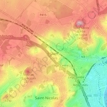
Name: Glain topographic map, elevation, terrain.
Location: Glain, Luik, Wallonië, 4000, België (50.62821 5.52186 50.66821 5.56186)
Average elevation: 152 m
Minimum elevation: 56 m
Maximum elevation: 227 m
Other topographic maps
Click on a map to view its topography, its elevation and its terrain.
Jupille-sur-Meuse
Jupille-sur-Meuse, Luik, Wallonië, 4000, België
Average elevation: 133 m