
Grivegnée topographic map
Interactive map
Click on the map to display elevation.
About this map
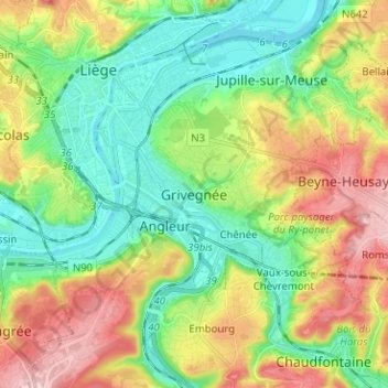
Name: Grivegnée topographic map, elevation, terrain.
Location: Grivegnée, Luik, Wallonië, 4000, België (50.57930 5.56476 50.65930 5.64476)
Average elevation: 130 m
Minimum elevation: 54 m
Maximum elevation: 258 m
Other topographic maps
Click on a map to view its topography, its elevation and its terrain.
Jupille-sur-Meuse
Jupille-sur-Meuse, Luik, Wallonië, 4000, België
Average elevation: 133 m