
Zilshausen topographic map
Interactive map
Click on the map to display elevation.
About this map
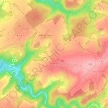
Name: Zilshausen topographic map, elevation, terrain.
Average elevation: 327 m
Minimum elevation: 210 m
Maximum elevation: 393 m
Other topographic maps
Click on a map to view its topography, its elevation and its terrain.
Fronhofen
Deutschland > Rheinland-Pfalz > Rhein-Hunsrück-Kreis
Fronhofen, Simmern-Rheinböllen, Rhein-Hunsrück-Kreis, Rheinland-Pfalz, Deutschland
Average elevation: 398 m
Simmern/Hunsrück
Deutschland > Rheinland-Pfalz > Rhein-Hunsrück-Kreis
Simmern/Hunsrück, Simmern-Rheinböllen, Rhein-Hunsrück-Kreis, Rheinland-Pfalz, 55469, Deutschland
Average elevation: 379 m
Sankt Goar
Deutschland > Rheinland-Pfalz > Rhein-Hunsrück-Kreis
Sankt Goar, Hunsrück-Mittelrhein, Rhein-Hunsrück-Kreis, Rheinland-Pfalz, Deutschland
Average elevation: 232 m
Hahn
Deutschland > Rheinland-Pfalz > Rhein-Hunsrück-Kreis > Hahn
Hahn, Kirchberg (Hunsrück), Rhein-Hunsrück-Kreis, Rheinland-Pfalz, Deutschland
Average elevation: 462 m
Boppard
Deutschland > Rheinland-Pfalz > Rhein-Hunsrück-Kreis > Boppard
Boppard, Rhein-Hunsrück-Kreis, Rheinland-Pfalz, 56154, Deutschland
Average elevation: 307 m