Geolocate

Newnan topographic map

Click on the map to display elevation.

About this map

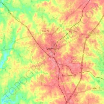
Name: Newnan topographic map, elevation, terrain.

Location: Newnan, Coweta County, Georgia, United States (33.33735 -84.83289 33.41625 -84.69393)

Average elevation: 272 m

Minimum elevation: 220 m

Maximum elevation: 311 m

Other topographic maps

Click on a map to view its topography, its elevation and its terrain.

Newnan Pines

United States > Georgia > Coweta County

Average elevation: 278 m

Sargent

United States > Georgia > Coweta County

Average elevation: 247 m

Lambert Field

United States > Georgia > Coweta County > Newnan

Average elevation: 285 m

Arnco Mills

United States > Georgia > Coweta County

Average elevation: 256 m

Gear up for your next adventure:

🦯Trekking Poles - Walking poles for hiking stability
🔌Fast Charging Adapters - Quickly top up all your gear before heading back into the field
🧤Hiking Gloves - Protective gloves for outdoor use
🔋Solar Power Banks - Charge your phone and GPS using the sun while deep in the bush
🧴SPF 50+ Bulk Sunscreen - Maximum protection for long-term outdoor exposure

As an Amazon Associate, this site earns from qualifying purchases at no extra cost to you.