
Gheorgheni topographic map
Interactive map
Click on the map to display elevation.
About this map
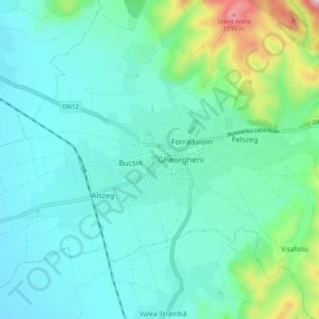
Name: Gheorgheni topographic map, elevation, terrain.
Location: Gheorgheni, Harghita, Romania (46.70775 25.55654 46.73490 25.64319)
Average elevation: 831 m
Minimum elevation: 764 m
Maximum elevation: 1,121 m
Other topographic maps
Click on a map to view its topography, its elevation and its terrain.
Carpathian Mountains
Carpathian Mountains, Toplița, Harghita, 535705, Romania
Average elevation: 980 m
Miercurea Ciuc
Romania > Harghita > Miercurea Ciuc
Miercurea Ciuc, Harghita, Romania
Average elevation: 689 m