Geolocate

Colo River topographic map

Click on the map to display elevation.

About this map

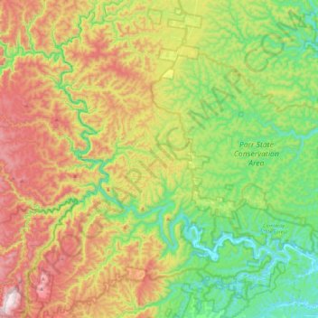
Name: Colo River topographic map, elevation, terrain.

Location: Colo River, New South Wales, Australia (-33.44295 150.46498 -33.19532 150.88713)

Average elevation: 337 m

Minimum elevation: 1 m

Maximum elevation: 889 m

New South Wales trails, hiking, mountain biking, running and outdoor activities

Other topographic maps

Click on a map to view its topography, its elevation and its terrain.

Sydney

Australia > New South Wales

Sydney's topography is characterized by a diverse landscape that seamlessly blends coastal features with inland plateaus. The city is divided into two primary regions: the relatively flat Cumberland Plain to the south and west of Sydney Harbour, and the elevated Hornsby Plateau to the north. The Cumberland…

Average elevation: 53 m

Lake Keepit

Australia > New South Wales

Average elevation: 357 m

Newcastle

Australia > New South Wales > Newcastle

Average elevation: 5 m

Bathurst

Australia > New South Wales

Average elevation: 760 m

Sydney

Australia > New South Wales > Sydney

Average elevation: 23 m

Tweed Heads

Australia > New South Wales

Average elevation: 3 m

Ocean Shores

Australia > New South Wales

Average elevation: 12 m

Mount Kosciuszko

Australia > New South Wales

Mount Kosciuszko is the highest summit in mainland Australia. Until 1977 it was possible to drive from Charlotte Pass to within a few metres of the summit, but in 1977 the road was closed to public motor vehicle access due to environmental concerns. The road is open from Charlotte Pass for walkers and cyclists…

Average elevation: 2,035 m

Port Macquarie

Australia > New South Wales

Average elevation: 5 m

Gordon's Bay

Australia > New South Wales > Sydney

Average elevation: 25 m

Torrington

Australia > New South Wales

Average elevation: 936 m

Katoomba

Australia > New South Wales

Average elevation: 904 m

Ku-ring-gai Council

Australia > New South Wales

Average elevation: 119 m

Sydney CBD

Australia > New South Wales > Sydney

Average elevation: 25 m

Newcastle

Australia > New South Wales

Average elevation: 9 m

Albury

Australia > New South Wales

Average elevation: 246 m

Byron Bay

Australia > New South Wales

Byron Bay, located in northeastern New South Wales, Australia, is characterized by diverse topography shaped by its geological history. The town is part of the erosion caldera of the ancient Tweed Volcano, which erupted approximately 23 million years ago, resulting in the rich volcanic soils that define the…

Average elevation: 7 m

Northern Beaches

Australia > New South Wales > Sydney

Average elevation: 67 m

Picton

Australia > New South Wales

Average elevation: 227 m

Thurgoona

Australia > New South Wales > Albury

Average elevation: 193 m

Leura

Australia > New South Wales

Leura's elevation of 985 metres (3,232 ft) AHD  leads to occasional snowfall in winter and a climate that reflects all four seasons distinctly.

Average elevation: 880 m

Mudgee

Australia > New South Wales

Average elevation: 535 m

Tweed Shire Council

Australia > New South Wales

Average elevation: 212 m

Lane Cove National Park

Australia > New South Wales > Sydney

The park includes areas of land which are part of Ku-ring-gai, Ryde, and Hornsby local government areas with small areas of the park in Willoughby, Lane Cove and Hunter's Hill local government areas on the banks of the lower reaches of the river. The park is surrounded on all sides by developed suburban areas…

Average elevation: 81 m

Sydney

Australia > New South Wales

Phillip had been given no instructions for urban development, but in July 1788 submitted a plan for the new town at Sydney Cove. It included a wide central avenue, a permanent Government House, law courts, hospital and other public buildings, but no provision for warehouses, shops, or other commercial…

Average elevation: 32 m

Dubbo

Australia > New South Wales

Average elevation: 318 m

Lake Munmorah

Australia > New South Wales

Average elevation: 10 m

Wollongong

Australia > New South Wales > Wollongong

Average elevation: 115 m

Bowral

Australia > New South Wales

Average elevation: 690 m

Goulburn

Australia > New South Wales

Owing to its elevation, Goulburn has an oceanic climate (Cfb) with warm summers and cool winters; with a high diurnal range. Its climate is variable much of the year, though generally dry with maximum temperatures ranging from 11.8 °C (53.2 °F) in July to 28.3 °C (82.9 °F) in January. Rainfall is…

Average elevation: 666 m

Grafton

Australia > New South Wales

Average elevation: 36 m

Manly

Australia > New South Wales

Average elevation: 17 m

Bondi

Australia > New South Wales > Sydney

Average elevation: 49 m

Hazelbrook

Australia > New South Wales

Hazelbrook is a town in New South Wales, Australia (Elevation: 675 metres) It is located 91 kilometres west of Sydney and 16 kilometres east of Katoomba in the Blue Mountains on the Great Western Highway.

Average elevation: 610 m

Nimmitabel

Australia > New South Wales

Average elevation: 1,051 m

Snowy Mountains

Australia > New South Wales

Average elevation: 2,011 m

Tamworth

Australia > New South Wales

Average elevation: 489 m

North Arm Cove

Australia > New South Wales

Average elevation: 32 m

Euchareena

Australia > New South Wales

Average elevation: 615 m

Termeil

Australia > New South Wales

Average elevation: 73 m

South Gundurimba

Australia > New South Wales

Average elevation: 19 m

Bonshaw

Australia > New South Wales

Average elevation: 426 m

Conjola Park

Australia > New South Wales

Average elevation: 28 m

Edensor Park

Australia > New South Wales > Sydney

Average elevation: 57 m

Young

Australia > New South Wales > Young

Average elevation: 473 m

Oberon Council

Australia > New South Wales

Average elevation: 899 m

Kempsey

Australia > New South Wales > Kempsey

Average elevation: 15 m

Surry Hills

Australia > New South Wales > Sydney

Average elevation: 35 m

South Windsor

Australia > New South Wales > Sydney

Average elevation: 16 m

Epping

Australia > New South Wales

Average elevation: 96 m

Hawkesbury River

Australia > New South Wales

Average elevation: 130 m

Eastern Suburbs

Australia > New South Wales > Sydney

Average elevation: 13 m

Melrose Park

Australia > New South Wales > Sydney

Average elevation: 23 m

Helensburgh

Australia > New South Wales > Helensburgh

Average elevation: 194 m

Parramatta

Australia > New South Wales

Average elevation: 22 m

Penrith

Australia > New South Wales > Penrith

Penrith is a city in New South Wales, Australia, located in Greater Western Sydney, 55 kilometres (31 mi) west of the Sydney central business district on the banks of the Nepean River, on the outskirts of the Cumberland Plain. Its elevation is 32 metres (105 ft).

Average elevation: 34 m

Oran Park

Australia > New South Wales > Sydney

Average elevation: 93 m

Forster

Australia > New South Wales > Forster

Average elevation: 4 m

Dubbo

Australia > New South Wales > Dubbo

Average elevation: 307 m

Barangaroo

Australia > New South Wales > Sydney

Average elevation: 15 m

Narooma

Australia > New South Wales > Narooma

Average elevation: 22 m

Hawks Nest

Australia > New South Wales > Hawks Nest

Average elevation: 2 m

Emu Plains

Australia > New South Wales > Sydney > Penrith

Average elevation: 27 m

Banora Point

Australia > New South Wales

Average elevation: 17 m

Bilgola Plateau

Australia > New South Wales

The suburb is mainly residential, with two small rows of shops, a small park and a primary school located on the top of the plateau. Bilgola Beach on the eastern side features a surf club and kiosk. Rising to an elevation of 150m above sea level, the suburb has views of the beach and the ocean on the eastern…

Average elevation: 37 m

Australian Alps

Australia > New South Wales

The Australian Alps are a mountain range in southeast Australia. It comprises an interim Australian bioregion, and is the highest mountain range in Australia. The range straddles the borders of eastern Victoria, southeastern New South Wales, and the Australian Capital Territory. It contains Australia's only…

Average elevation: 2,037 m

Milperra

Australia > New South Wales > Sydney

Average elevation: 8 m

Hunter Valley

Australia > New South Wales > Cessnock

Average elevation: 70 m

Cessnock

Australia > New South Wales

Average elevation: 142 m

Silverdale

Australia > New South Wales > Sydney

Average elevation: 149 m

Cowra

Australia > New South Wales

Average elevation: 379 m

Mount Solitary

Australia > New South Wales

Average elevation: 600 m

Upper North Shore

Australia > New South Wales > Sydney

Average elevation: 119 m

Lower North Shore

Australia > New South Wales > Sydney

Average elevation: 45 m

Lewisham

Australia > New South Wales > Sydney

Average elevation: 28 m

Willoughby

Australia > New South Wales > Sydney

Average elevation: 80 m

Darling Harbour

Australia > New South Wales > Sydney

Average elevation: 23 m

Cawongla

Australia > New South Wales

Average elevation: 208 m

Gear up for your next adventure:

🦟Insect Repellent - Protection against insects
🚴Cycling Backpacks - Backpacks for cyclists
🚗Car Camping Gear - Equipment for vehicle camping
🏕️Camping Gear - Essential camping equipment
🥶Thermal Beanies - Warm hats for cold hikes

As an Amazon Associate, this site earns from qualifying purchases at no extra cost to you.