
Make a donation
Gear up for your next adventure:
As an Amazon Associate, this site earns from qualifying purchases at no extra cost to you.
Kulpi topographic map
Click on the map to display elevation.
Make a donation
Gear up for your next adventure:
As an Amazon Associate, this site earns from qualifying purchases at no extra cost to you.
Kulpi
Kulpi CD block is located at 22°04′53″N 88°14′42″E / 22.0815°N 88.2449°E / 22.0815; 88.2449. It has an average elevation of 6 metres (20 ft).
Make a donation
Gear up for your next adventure:
As an Amazon Associate, this site earns from qualifying purchases at no extra cost to you.
About this map
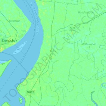
Name: Kulpi topographic map, elevation, terrain.
Location: Kulpi, South 24 Parganas District, West Bengal, India (21.91597 88.15477 22.16698 88.31583)
Average elevation: 3 m
Minimum elevation: -2 m
Maximum elevation: 12 m
Make a donation
Gear up for your next adventure:
As an Amazon Associate, this site earns from qualifying purchases at no extra cost to you.
Other topographic maps
Click on a map to view its topography, its elevation and its terrain.
Diamond Harbour
India > West Bengal > Diamond Harbour - I
Diamond Harbour is located at 22°11′28″N 88°11′26″E / 22.1910091°N 88.1904741°E / 22.1910091; 88.1904741. It has an average elevation of 8 metres (26 ft).
Average elevation: 3 m
Make a donation
Gear up for your next adventure:
As an Amazon Associate, this site earns from qualifying purchases at no extra cost to you.