Indian Wells topographic map
Click on the map to display elevation.
About this map
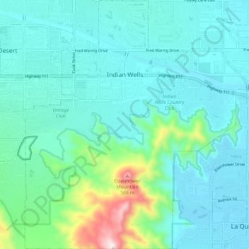
Name: Indian Wells topographic map, elevation, terrain.
Average elevation: 118 m
Minimum elevation: 9 m
Maximum elevation: 672 m
Other topographic maps
Click on a map to view its topography, its elevation and its terrain.
Little Lake
United States > California > Riverside County > Lake Crest Estates
Average elevation: 553 m


Coachella Valley
United States > California > Riverside County > Palm Desert
The area is surrounded on the southwest by the Santa Rosa Mountains, by the San Jacinto Mountains to the west, the Little San Bernardino Mountains to the east and San Gorgonio Mountain to the north. These mountains peak at around 11,000 feet (3,400 m) and tend to average between 5,000 and 7,000 feet (1,500 and…
Average elevation: 72 m


Highgrove
United States > California > Riverside County > Grand Terrace > Highgrove
The city of Riverside, California has plans to annex Highgrove in the near future. Currently at Spring Mountain Ranch community, Avalon, Cambria, and Sonoma (all opening by February 2022) are the three, newest largest master-planned communities being built at the Highgrove eastside area. Soon, Compass and…
Average elevation: 316 m
Gale Webb Action Sports Park
United States > California > Riverside County > Menifee
Average elevation: 461 m
San Jacinto Peak
United States > California > Riverside County
San Jacinto Peak is one of the most topographically prominent peaks in the United States, and is ranked the sixth most prominent peak in the 48 contiguous states. According to John W. Robinson and Bruce D. Risher, authors of The San Jacintos, "No Southern California hiker worth his salt would miss climbing…
Average elevation: 2,880 m


Cherry Valley
United States > California > Riverside County > Beaumont
With an elevation of 2,980 feet above sea level, Cherry Valley is at the highest point on the San Gorgonio Pass between San Bernardino and Palm Springs. According to the United States Census Bureau, the CDP has a total area of 8.1 square miles (21 km2), all of it land.
Average elevation: 942 m
Mountain Center
United States > California > Riverside County
It lies centered on the junction of State Route 74 and State Route 243 in the southern division of San Bernardino National Forest. Mountain Center lies just north of Lake Hemet, midway between Hemet and Palm Desert, just south of the town of Idyllwild, and it is southeast of the city of Riverside, the county…
Average elevation: 1,476 m
Pine Cove
United States > California > Riverside County > Idyllwild-Pine Cove
Average elevation: 1,791 m
Idyllwild-Pine Cove
United States > California > Riverside County
"Mile-high Idyllwild" is a mountain resort about one mile (1600 m) in altitude. Idyllwild is flanked by two large rock formations, Tahquitz Rock (also known as Lily Rock) and Suicide Rock, which are famous in Southern California rock-climbing circles.[citation needed] It offers no skiing, so "the Hill" has…
Average elevation: 1,746 m

Coachella Valley
United States > California > Riverside County > Palm Desert
The area is surrounded on the southwest by the Santa Rosa Mountains, by the San Jacinto Mountains to the west, the Little San Bernardino Mountains to the east and San Gorgonio Mountain to the north. These mountains peak at around 11,000 feet (3,400 m) and tend to average between 5,000 and 7,000 feet (1,500 and…
Average elevation: 72 m
Whitewater
United States > California > Riverside County
Whitewater (formerly White Water) is a census-designated place in Riverside County, California. It is directly off Interstate 10 halfway between North Palm Springs and Cabazon on the way from Palm Springs to Los Angeles. It is known as the site of the San Gorgonio Pass Wind Farm. The ZIP Code is 92282, and the…
Average elevation: 451 m
San Jacinto Mountains
United States > California > Riverside County
The San Jacinto Mountains, like the neighboring San Bernardino Mountains, are a humid island above the surrounding desert and semi-desert. Annual precipitation ranges from about 15 inches at the western base (and only 6 inches on the eastern, desert base) to as much as 32 inches above 5,500 feet (the mountain…
Average elevation: 2,687 m
Aguanga
United States > California > Riverside County
Aguanga (/əˈwɑːŋ.ɡə/; Luiseño: Awáanga, meaning "dog place") is a census-designated place located within the Inland Empire in Riverside County, California. It is located about 18 miles (29 km) east of Temecula and 22 miles (35 km) south-southeast of Hemet. Aguanga lies at an elevation of 1955 feet…
Average elevation: 657 m
El Cerrito
United States > California > Riverside County
According to the United States Census Bureau, the city has a total area of 3.7 square miles (9.6 km2), all of it land. The city ranges in elevation from 20 to 934 feet, with an average elevation of 69 feet (21 m).
Average elevation: 293 m

San Jacinto / Lake Perris Core Reserve
United States > California > Riverside County > Moreno Valley
Average elevation: 477 m
San Jacinto Mountains
United States > California > Riverside County
The San Jacinto Mountains, like the neighboring San Bernardino Mountains, are a humid island above the surrounding desert and semi-desert. Annual precipitation ranges from about 15 inches at the western base (and only 6 inches on the eastern, desert base) to as much as 32 inches above 5,500 feet (the mountain…
Average elevation: 2,687 m
Menifee
United States > California > Riverside County
The city is centrally located in Southern California in the Menifee Valley. It is almost 15 miles (24 km) north of Temecula and just north of Murrieta. Menifee is roughly 46 square miles (100 km2) in size and has an elevation of 1,424 feet (434 m). The incorporated City of Menifee includes the communities of…
Average elevation: 456 m