Make a donation
Gear up for your next adventure:
As an Amazon Associate, this site earns from qualifying purchases at no extra cost to you.
Long Reef topographic map
Click on the map to display elevation.
Make a donation
Gear up for your next adventure:
As an Amazon Associate, this site earns from qualifying purchases at no extra cost to you.
About this map
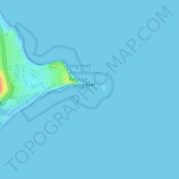
Name: Long Reef topographic map, elevation, terrain.
Average elevation: 1 m
Minimum elevation: -1 m
Maximum elevation: 42 m
New South Wales trails, hiking, mountain biking, running and outdoor activities
Make a donation
Gear up for your next adventure:
As an Amazon Associate, this site earns from qualifying purchases at no extra cost to you.
Other topographic maps
Click on a map to view its topography, its elevation and its terrain.
Make a donation
Gear up for your next adventure:
As an Amazon Associate, this site earns from qualifying purchases at no extra cost to you.
Make a donation
Gear up for your next adventure:
As an Amazon Associate, this site earns from qualifying purchases at no extra cost to you.
Make a donation
Gear up for your next adventure:
As an Amazon Associate, this site earns from qualifying purchases at no extra cost to you.
Make a donation
Gear up for your next adventure:
As an Amazon Associate, this site earns from qualifying purchases at no extra cost to you.
Make a donation
Gear up for your next adventure:
As an Amazon Associate, this site earns from qualifying purchases at no extra cost to you.
Make a donation
Gear up for your next adventure:
As an Amazon Associate, this site earns from qualifying purchases at no extra cost to you.
Make a donation
Gear up for your next adventure:
As an Amazon Associate, this site earns from qualifying purchases at no extra cost to you.
Penrith
Australia > New South Wales > Sydney > Penrith
Penrith is a city in New South Wales, Australia, located in Greater Western Sydney, 55 kilometres (31 mi) west of the Sydney central business district on the banks of the Nepean River, on the outskirts of the Cumberland Plain. Its elevation is 32 metres (105 ft).
Average elevation: 34 m
Make a donation
Gear up for your next adventure:
As an Amazon Associate, this site earns from qualifying purchases at no extra cost to you.
Lane Cove National Park
Australia > New South Wales > Sydney
The park includes areas of land which are part of Ku-ring-gai, Ryde, and Hornsby local government areas with small areas of the park in Willoughby, Lane Cove and Hunter's Hill local government areas on the banks of the lower reaches of the river. The park is surrounded on all sides by developed suburban areas…
Average elevation: 81 m
Make a donation
Gear up for your next adventure:
As an Amazon Associate, this site earns from qualifying purchases at no extra cost to you.
Woodford
Australia > New South Wales > Sydney
Woodford is a village in the Blue Mountains in New South Wales, Australia, about 90 kilometres west of Sydney. Its elevation is 609 metres (1,998 ft) above sea level. It is situated on the Great Western Highway and has a railway station (opened in 1868 as Buss's Platform) on the Main Western railway line…
Average elevation: 544 m
Make a donation
Gear up for your next adventure:
As an Amazon Associate, this site earns from qualifying purchases at no extra cost to you.
Make a donation
Gear up for your next adventure:
As an Amazon Associate, this site earns from qualifying purchases at no extra cost to you.
Make a donation
Gear up for your next adventure:
As an Amazon Associate, this site earns from qualifying purchases at no extra cost to you.
Make a donation
Gear up for your next adventure:
As an Amazon Associate, this site earns from qualifying purchases at no extra cost to you.
Mount Colah
Australia > New South Wales > Sydney
Mount Colah is 5 km north of Hornsby, the nearest major town centre. It is one of the most northerly suburbs of Sydney and is where the "Welcome to Sydney" sign is located. Mount Colah is the second highest suburb in Sydney by elevation. Considered one of Sydney's leafier suburbs, streets are clustered around…
Average elevation: 152 m
Make a donation
Gear up for your next adventure:
As an Amazon Associate, this site earns from qualifying purchases at no extra cost to you.
Make a donation
Gear up for your next adventure:
As an Amazon Associate, this site earns from qualifying purchases at no extra cost to you.
Make a donation
Gear up for your next adventure:
As an Amazon Associate, this site earns from qualifying purchases at no extra cost to you.
Make a donation
Gear up for your next adventure:
As an Amazon Associate, this site earns from qualifying purchases at no extra cost to you.
Make a donation
Gear up for your next adventure:
As an Amazon Associate, this site earns from qualifying purchases at no extra cost to you.
Canterbury-Bankstown Council
Australia > New South Wales > Sydney
Within the same year 16 US fighter planes that were based at Bankstown airport flew over Canterbury racecourse at low altitude during a race meet. This was to let the Australian public, especially those of the district to know that they, their allies were there for their protection. Regardless of these events,…
Average elevation: 26 m
Make a donation
Gear up for your next adventure:
As an Amazon Associate, this site earns from qualifying purchases at no extra cost to you.
Jamison Valley
Australia > New South Wales > Sydney > Leura
South of Mount Solitary, the valley sprawls through Cedar and Kedumba Valley down to Coxs River and Lake Burragorang, the lake that was created when Warragamba Dam was built. There is a 3 kilometres (1.9 mi) prohibited area around the river and lake to protect Sydney's water supply. Around this area there is a…
Average elevation: 578 m
Make a donation
Gear up for your next adventure:
As an Amazon Associate, this site earns from qualifying purchases at no extra cost to you.
Make a donation
Gear up for your next adventure:
As an Amazon Associate, this site earns from qualifying purchases at no extra cost to you.
Make a donation
Gear up for your next adventure:
As an Amazon Associate, this site earns from qualifying purchases at no extra cost to you.
Make a donation
Gear up for your next adventure:
As an Amazon Associate, this site earns from qualifying purchases at no extra cost to you.
Smithfield
Australia > New South Wales > Sydney
Established in 1836, Smithfield was the first major settlement of the Fairfield LGA. The original 1838 summary plan of Smithfield shows the suburb laid out in a grid pattern with most of the streets having the same names as they do today. Its altitude ranges from 21 to 48 m (69 to 157 ft) above sea level.…
Average elevation: 33 m
Make a donation
Gear up for your next adventure:
As an Amazon Associate, this site earns from qualifying purchases at no extra cost to you.
Make a donation
Gear up for your next adventure:
As an Amazon Associate, this site earns from qualifying purchases at no extra cost to you.
