Geolocate
Thank you for supporting this site ❤️Make a donation

St Leonards topographic map

Click on the map to display elevation.

About this map

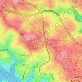
Name: St Leonards topographic map, elevation, terrain.

Location: St Leonards, Sydney, Willoughby City Council, New South Wales, 2065, Australia (-33.82808 151.18675 -33.81654 151.19908)

Average elevation: 69 m

Minimum elevation: -1 m

Maximum elevation: 107 m

Other topographic maps

Click on a map to view its topography, its elevation and its terrain.

Sydney

Australia > New South Wales

Sydney, Council of the City of Sydney, New South Wales, 2000, Australia

Average elevation: 23 m

Parramatta River

Australia > New South Wales > Sydney

Parramatta River, Brodie Street, Rydalmere, Sydney, City of Parramatta Council, New South Wales, 2116, Australia

Average elevation: 43 m

Baulkham Hills

Australia > New South Wales > Sydney

Baulkham Hills, Sydney, The Hills Shire Council, New South Wales, 2153, Australia

Average elevation: 93 m

Katoomba

Australia > New South Wales > Sydney

Katoomba, Sydney, Blue Mountains City Council, New South Wales, 2780, Australia

Average elevation: 912 m

Hawkesbury River

Australia > New South Wales > Sydney

Hawkesbury River, Sydney, The Hills Shire Council, New South Wales, 2083, Australia

Average elevation: 117 m

Hunters Hill

Australia > New South Wales > Sydney

Hunters Hill, Sydney, The Council of the Municipality of Hunters Hill, New South Wales, 2110, Australia

Average elevation: 24 m

Northern Beaches

Australia > New South Wales > Sydney

Northern Beaches, Sydney, Northern Beaches Council, New South Wales, Australia

Average elevation: 67 m

Penrith

Australia > New South Wales > Sydney

Penrith, Sydney, Penrith City Council, New South Wales, 2750, Australia

Average elevation: 34 m

Marsden Park

Australia > New South Wales > Sydney

Marsden Park, Sydney, Blacktown City Council, New South Wales, 2765, Australia

Average elevation: 31 m

Dantes Glen

Australia > New South Wales > Sydney > Lawson

Dantes Glen, Lawson, Sydney, Blue Mountains City Council, New South Wales, 2783, Australia

Average elevation: 689 m

Riverstone

Australia > New South Wales > Sydney

Riverstone, Sydney, Blacktown City Council, New South Wales, 2765, Australia

Average elevation: 26 m

Mosman

Australia > New South Wales > Sydney

Mosman, Sydney, Mosman Municipal Council, New South Wales, 2088, Australia

Average elevation: 28 m

Box Hill

Australia > New South Wales > Sydney

Box Hill, Hills District, Sydney, The Hills Shire Council, New South Wales, 2765, Australia

Average elevation: 45 m

Ku-ring-gai Chase National Park

Australia > New South Wales > Sydney

Ku-ring-gai Chase National Park, Sydney, Northern Beaches Council, New South Wales, Australia

Average elevation: 83 m

Sydney Harbour National Park

Australia > New South Wales > Sydney

Sydney Harbour National Park, Mosman, Sydney, Mosman Municipal Council, Lower North Shore, New South Wales, 2088, Australia

Average elevation: 16 m

Pitt Town

Australia > New South Wales > Sydney

Pitt Town, Sydney, Hawkesbury City Council, New South Wales, 2756, Australia

Average elevation: 19 m

In order to remain free and to keep improving, this site uses cookies created by Google to compile visit statistics and display personalized advertisements.

How is the collected data used?