
Make a donation
Gear up for your next adventure:
As an Amazon Associate, this site earns from qualifying purchases at no extra cost to you.
Butzbach topographic map
Click on the map to display elevation.
Make a donation
Gear up for your next adventure:
As an Amazon Associate, this site earns from qualifying purchases at no extra cost to you.
Butzbach
Butzbach besteht aus den Stadtteilen Bodenrod, Butzbach (Kernstadt), Ebersgöns, Fauerbach vor der Höhe, Griedel, Hausen-Oes, Hoch-Weisel, Kirch-Göns, Maibach, Münster, Nieder-Weisel, Ostheim, Pohl-Göns und Wiesental.
Make a donation
Gear up for your next adventure:
As an Amazon Associate, this site earns from qualifying purchases at no extra cost to you.
About this map
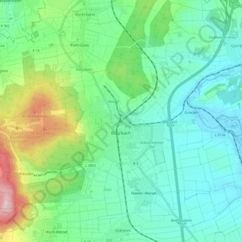
Name: Butzbach topographic map, elevation, terrain.
Location: Butzbach, Wetteraukreis, Hessen, 35510, Deutschland (50.42164 8.57394 50.45372 8.69291)
Average elevation: 225 m
Minimum elevation: 140 m
Maximum elevation: 478 m
Make a donation
Gear up for your next adventure:
As an Amazon Associate, this site earns from qualifying purchases at no extra cost to you.
Other topographic maps
Click on a map to view its topography, its elevation and its terrain.
Butzbach
Deutschland > Hessen > Wetteraukreis > Butzbach > Butzbach
Butzbach besteht aus den Stadtteilen Bodenrod, Butzbach (Kernstadt), Ebersgöns, Fauerbach vor der Höhe, Griedel, Hausen-Oes, Hoch-Weisel, Kirch-Göns, Maibach, Münster, Nieder-Weisel, Ostheim, Pohl-Göns und Wiesental.
Average elevation: 226 m
Ebersgöns
Deutschland > Hessen > Wetteraukreis > Butzbach > Ebersgöns
Bodenrod | Ebersgöns | Fauerbach vor der Höhe | Griedel | Hausen-Oes | Hoch-Weisel | Kirch-Göns | Maibach | Münster | Nieder-Weisel | Ostheim | Pohl-Göns | Wiesental
Average elevation: 287 m
Make a donation
Gear up for your next adventure:
As an Amazon Associate, this site earns from qualifying purchases at no extra cost to you.
Ostheim
Deutschland > Hessen > Wetteraukreis > Butzbach > Ostheim
Bodenrod | Ebersgöns | Fauerbach vor der Höhe | Griedel | Hausen-Oes | Hoch-Weisel | Kirch-Göns | Maibach | Münster | Nieder-Weisel | Ostheim | Pohl-Göns | Wiesental
Average elevation: 201 m