
Rapid City topographic map
Interactive map
Click on the map to display elevation.
About this map
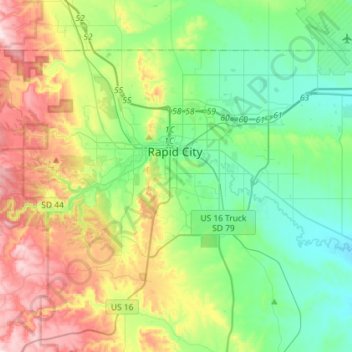
Name: Rapid City topographic map, elevation, terrain.
Location: Rapid City, Pennington County, South Dakota, United States (43.99492 -103.32635 44.13679 -103.03791)
Average elevation: 1,068 m
Minimum elevation: 914 m
Maximum elevation: 1,390 m
Rapid City features a temperate semi-arid climate (Köppen: BSk) bordering on a hot-summer humid continental climate (Köppen: Dwa), and is part of USDA Hardiness zone 5b. Its location makes its climate unlike both the higher elevations of the Black Hills to the west and the Great Plains to the east. It is characterized by long arid summers and long dry winters, with short but distinct spring and autumn seasons. Precipitation averages 17.44 inches or 443.0 millimetres annually, but has historically ranged from 9.12 inches or 231.6 millimetres in 1974 to 27.70 inches or 703.6 millimetres in 1946.
Other topographic maps
Click on a map to view its topography, its elevation and its terrain.
Rapid Creek
United States > South Dakota > Pennington County
Rapid Creek, Pennington County, South Dakota, United States
Average elevation: 1,372 m