
Make a donation
Gear up for your next adventure:
As an Amazon Associate, this site earns from qualifying purchases at no extra cost to you.
Saharanpur topographic map
Click on the map to display elevation.
Make a donation
Gear up for your next adventure:
As an Amazon Associate, this site earns from qualifying purchases at no extra cost to you.
Saharanpur
Saharanpur is located at 29°58′N 77°33′E / 29.97°N 77.55°E / 29.97; 77.55, about 130 kilometres (81 mi) south-southeast from Chandigarh and 170 kilometres (110 mi) north-northeast from Delhi. It has an average elevation of 284 metres (932 ft). It is bordered by Yamunanagar and Karnal districts of Haryana to the west, Sirmaur district of Himachal Pradesh to the northwest, Dehradun district of Uttarakhand to the north, Haridwar district of Uttarakhand to the east and Muzaffarnagar and Shamli districts to the south.
Make a donation
Gear up for your next adventure:
As an Amazon Associate, this site earns from qualifying purchases at no extra cost to you.
About this map
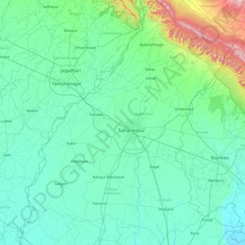
Name: Saharanpur topographic map, elevation, terrain.
Location: Saharanpur, Uttar Pradesh, India (29.56929 77.12063 30.40638 77.94629)
Average elevation: 307 m
Minimum elevation: 226 m
Maximum elevation: 884 m
Make a donation
Gear up for your next adventure:
As an Amazon Associate, this site earns from qualifying purchases at no extra cost to you.
Other topographic maps
Click on a map to view its topography, its elevation and its terrain.
Varanasi
India > Uttar Pradesh > Sadar
Varanasi is located at an elevation of 80.71 metres (264.8 ft) in the centre of the Ganges valley of North India, in the Eastern part of the state of Uttar Pradesh, along the left crescent-shaped bank of the Ganges, averaging between 15 metres (50 ft) and 21 metres (70 ft) above the river. The city is the…
Average elevation: 77 m
Make a donation
Gear up for your next adventure:
As an Amazon Associate, this site earns from qualifying purchases at no extra cost to you.