
Make a donation
Gear up for your next adventure:
As an Amazon Associate, this site earns from qualifying purchases at no extra cost to you.
Faizabad topographic map
Click on the map to display elevation.
Make a donation
Gear up for your next adventure:
As an Amazon Associate, this site earns from qualifying purchases at no extra cost to you.
About this map
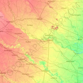
Name: Faizabad topographic map, elevation, terrain.
Location: Faizabad, Ayodhya District, Uttar Pradesh, 224188, India (26.05000 81.30000 27.45000 82.70000)
Average elevation: 101 m
Minimum elevation: 79 m
Maximum elevation: 126 m
Make a donation
Gear up for your next adventure:
As an Amazon Associate, this site earns from qualifying purchases at no extra cost to you.
Other topographic maps
Click on a map to view its topography, its elevation and its terrain.
Make a donation
Gear up for your next adventure:
As an Amazon Associate, this site earns from qualifying purchases at no extra cost to you.
Make a donation
Gear up for your next adventure:
As an Amazon Associate, this site earns from qualifying purchases at no extra cost to you.
Saharanpur
Saharanpur is located at 29°58′N 77°33′E / 29.97°N 77.55°E / 29.97; 77.55, about 130 kilometres (81 mi) south-southeast from Chandigarh and 170 kilometres (110 mi) north-northeast from Delhi. It has an average elevation of 284 metres (932 ft). It is bordered by Yamunanagar and Karnal districts…
Average elevation: 307 m