
San Miguelito topographic map
Interactive map
Click on the map to display elevation.
About this map
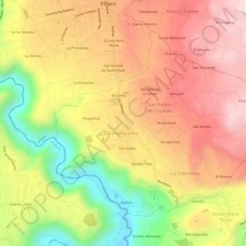
Name: San Miguelito topographic map, elevation, terrain.
Average elevation: 2,702 m
Minimum elevation: 2,234 m
Maximum elevation: 3,069 m
Other topographic maps
Click on a map to view its topography, its elevation and its terrain.
Pillaro
Ecuador > Tungurahua > Santiago de Pillaro
Pillaro, Santiago de Pillaro, Tungurahua, Ecuador
Average elevation: 2,851 m
San Andrés
Ecuador > Tungurahua > Santiago de Pillaro
San Andrés, Santiago de Pillaro, Tungurahua, Ecuador
Average elevation: 2,894 m