
San Andrés topographic map
Interactive map
Click on the map to display elevation.
About this map
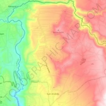
Name: San Andrés topographic map, elevation, terrain.
Location: San Andrés, Santiago de Pillaro, Tungurahua, Ecuador (-1.14451 -78.57643 -1.05814 -78.49384)
Average elevation: 2,894 m
Minimum elevation: 2,424 m
Maximum elevation: 3,291 m
Other topographic maps
Click on a map to view its topography, its elevation and its terrain.
Pillaro
Ecuador > Tungurahua > Santiago de Pillaro
Pillaro, Santiago de Pillaro, Tungurahua, Ecuador
Average elevation: 2,851 m
San Miguelito
Ecuador > Tungurahua > Santiago de Pillaro
San Miguelito, Santiago de Pillaro, Tungurahua, 180503, Ecuador
Average elevation: 2,702 m