
Mount Liebig topographic map
Interactive map
Click on the map to display elevation.
About this map
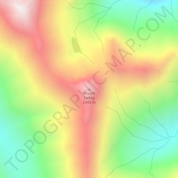
Name: Mount Liebig topographic map, elevation, terrain.
Location: Mount Liebig, Flathead County, Montana, United States (48.30797 -113.73293 48.30807 -113.73283)
Average elevation: 1,968 m
Minimum elevation: 1,434 m
Maximum elevation: 2,544 m
Other topographic maps
Click on a map to view its topography, its elevation and its terrain.
Kalispell
United States > Montana > Flathead County
Kalispell, Flathead County, Montana, United States
Average elevation: 934 m
Lakeside
United States > Montana > Flathead County
Lakeside, Flathead County, Montana, 59922, United States
Average elevation: 1,034 m
Bowman Lake
United States > Montana > Flathead County
Bowman Lake, Flathead County, Montana, United States
Average elevation: 1,639 m
Martin City
United States > Montana > Flathead County > Martin City
Martin City, Flathead County, Montana, 59926, United States
Average elevation: 989 m
Columbia Falls
United States > Montana > Flathead County
Columbia Falls, Flathead County, Montana, 59912, United States
Average elevation: 934 m
Whitefish
United States > Montana > Flathead County
Whitefish, Flathead County, Montana, United States
Average elevation: 1,073 m
La Salle
United States > Montana > Flathead County > La Salle
La Salle, Flathead County, Montana, United States
Average elevation: 906 m
Kalispell
United States > Montana > Flathead County > Kalispell
Kalispell, Flathead County, Montana, 59901-4451, United States
Average elevation: 1,055 m
Agassiz Glacier
United States > Montana > Flathead County
Agassiz Glacier, Flathead County, Montana, United States
Average elevation: 2,376 m
Vulture Glacier
United States > Montana > Flathead County
Vulture Glacier, Flathead County, Montana, United States
Average elevation: 2,381 m