
Kalispell topographic map
Interactive map
Click on the map to display elevation.
About this map
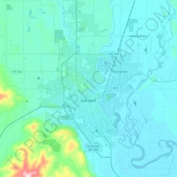
Name: Kalispell topographic map, elevation, terrain.
Location: Kalispell, Flathead County, Montana, United States (48.13902 -114.37390 48.28449 -114.26881)
Average elevation: 934 m
Minimum elevation: 879 m
Maximum elevation: 1,394 m
Kalispell is located at 48°11′52″N 114°18′58″W / 48.19778°N 114.31611°W / 48.19778; -114.31611 (48.197801, −114.316068), at an elevation of 2,956 feet (901 m).
Other topographic maps
Click on a map to view its topography, its elevation and its terrain.
Tunnel Creek
United States > Montana > Flathead County
Tunnel Creek, Flathead County, Montana, United States
Average elevation: 1,211 m
Lake McDonald
United States > Montana > Flathead County
Lake McDonald, Flathead County, Montana, United States
Average elevation: 1,209 m
West Glacier
United States > Montana > Flathead County > West Glacier
West Glacier, Flathead County, Montana, 59936, United States
Average elevation: 1,201 m