
Make a donation
Gear up for your next adventure:
As an Amazon Associate, this site earns from qualifying purchases at no extra cost to you.
Gusterath topographic map
Click on the map to display elevation.
Make a donation
Gear up for your next adventure:
As an Amazon Associate, this site earns from qualifying purchases at no extra cost to you.
About this map
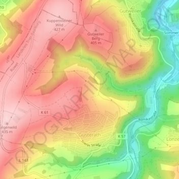
Name: Gusterath topographic map, elevation, terrain.
Average elevation: 332 m
Minimum elevation: 182 m
Maximum elevation: 436 m
Make a donation
Gear up for your next adventure:
As an Amazon Associate, this site earns from qualifying purchases at no extra cost to you.
Other topographic maps
Click on a map to view its topography, its elevation and its terrain.
Sandkopf
Deutschland > Rheinland-Pfalz > Landkreis Trier-Saarburg > Neuhütten
Average elevation: 683 m
Make a donation
Gear up for your next adventure:
As an Amazon Associate, this site earns from qualifying purchases at no extra cost to you.
Wehr (Mosel)
Deutschland > Rheinland-Pfalz > Landkreis Trier-Saarburg
Auf einer Moselanhöhe im Ortsteil Kreuzweiler erhebt sich das Schloss Thorn. Der Name stammt vom Lateinischen turis (= Turm). Dieser wurde vor ungefähr 2000 Jahren zum Schutz einer Furt als Moselübergang errichtet. Die Burg wurde im 13. Jahrhundert erbaut. Bauliche Erweiterungen im 16. und 17. Jahrhundert…
Average elevation: 201 m
Serrig
Deutschland > Rheinland-Pfalz > Landkreis Trier-Saarburg > Serrig > Serrig
Average elevation: 261 m
Make a donation
Gear up for your next adventure:
As an Amazon Associate, this site earns from qualifying purchases at no extra cost to you.
Klausenhöhle
Deutschland > Rheinland-Pfalz > Landkreis Trier-Saarburg > Kordel
Average elevation: 266 m
Make a donation
Gear up for your next adventure:
As an Amazon Associate, this site earns from qualifying purchases at no extra cost to you.
Kastelaun
Deutschland > Rheinland-Pfalz > Landkreis Trier-Saarburg > Schweich
Average elevation: 255 m
Make a donation
Gear up for your next adventure:
As an Amazon Associate, this site earns from qualifying purchases at no extra cost to you.
Panzbruch bei Greimerath
Deutschland > Rheinland-Pfalz > Landkreis Trier-Saarburg > Greimerath
Average elevation: 465 m
Grimburgerhof
Deutschland > Rheinland-Pfalz > Landkreis Trier-Saarburg > Grimburg
Average elevation: 499 m
Make a donation
Gear up for your next adventure:
As an Amazon Associate, this site earns from qualifying purchases at no extra cost to you.
Teufelskopf
Deutschland > Rheinland-Pfalz > Landkreis Trier-Saarburg > Waldweiler
Der Teufelskopf ist laut einem auf topographischen Karten verzeichneten trigonometrischem Punkt im Bereich des Senders Teufelskopf mindestens 695 m hoch. Wenige Meter südwestlich vom Gipfel befindet sich eine 694,3 m hohe Stelle. Im Südwesten der Gipfelregion ist auf derartigen Karten etwa in Ovalform eine…
Average elevation: 610 m
Scharfenberg
Deutschland > Rheinland-Pfalz > Landkreis Trier-Saarburg > Irsch
Average elevation: 305 m
Bilzingen
Deutschland > Rheinland-Pfalz > Landkreis Trier-Saarburg > Bilzingen
Average elevation: 340 m
Hohe Wurzel
Deutschland > Rheinland-Pfalz > Landkreis Trier-Saarburg > Beuren (Hochwald)
Die Hohe Wurzel ist eher ein langgestreckter Höhenzug als ein markanter Berg, neben dem höheren Rösterkopf wirkt sie wie dessen Nordostausläufer. Auffallend ist eine Höchstspannungsfreileitung zwischen den Umspannwerken Uchtelfangen und Niederstedem, die die Hohe Wurzel in einer Waldschneise fast zentral…
Average elevation: 612 m
Make a donation
Gear up for your next adventure:
As an Amazon Associate, this site earns from qualifying purchases at no extra cost to you.
Hochwaldhof
Deutschland > Rheinland-Pfalz > Landkreis Trier-Saarburg > Züsch > Hochwaldhof
Average elevation: 561 m
Pellenberg
Deutschland > Rheinland-Pfalz > Landkreis Trier-Saarburg > Merzkirchen
Average elevation: 347 m
Eichenweg
Deutschland > Rheinland-Pfalz > Landkreis Trier-Saarburg > Greimerath
Average elevation: 461 m
Make a donation
Gear up for your next adventure:
As an Amazon Associate, this site earns from qualifying purchases at no extra cost to you.
Hosteberg
Deutschland > Rheinland-Pfalz > Landkreis Trier-Saarburg > Saarburg
Average elevation: 319 m
Ackersberg
Deutschland > Rheinland-Pfalz > Landkreis Trier-Saarburg > Longuich
Average elevation: 196 m