
Stroud topographic map
Click on the map to display elevation.
About this map
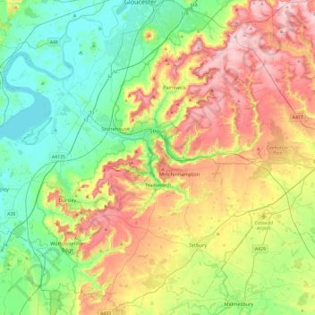
Name: Stroud topographic map, elevation, terrain.
Location: Stroud, Gloucestershire, England, United Kingdom (51.58984 -2.54081 51.85046 -2.06871)
Average elevation: 113 m
Minimum elevation: 1 m
Maximum elevation: 302 m
Other topographic maps
Click on a map to view its topography, its elevation and its terrain.
Ruardean Hill
United Kingdom > England > Gloucestershire > Forest of Dean > Drybrook
Average elevation: 204 m
Stow-on-the-Wold
United Kingdom > England > Gloucestershire > Cotswold District
Average elevation: 163 m
Joyford
United Kingdom > England > Gloucestershire > Forest of Dean > Berry Hill
Average elevation: 188 m
Jubilee Playing Field & Athletics Track
United Kingdom > England > Gloucestershire > Stroud > Cam > Draycott
Average elevation: 45 m
Duntisbourne Abbots
United Kingdom > England > Gloucestershire > Cotswold District
Average elevation: 204 m
Lower Slaughter
United Kingdom > England > Gloucestershire > Cotswold District
Average elevation: 160 m
Bream Meend
United Kingdom > England > Gloucestershire > Forest of Dean > Bream
Average elevation: 140 m
Highbury
United Kingdom > England > Gloucestershire > Forest of Dean > Lydney > Allaston
Average elevation: 65 m
Grange Village
United Kingdom > England > Gloucestershire > Forest of Dean > Littledean
Average elevation: 98 m
Calcot
United Kingdom > England > Gloucestershire > Cotswold District > Coln Rogers
Average elevation: 151 m
Bamfurlong
United Kingdom > England > Gloucestershire > Tewkesbury > Staverton
Average elevation: 34 m
Saunders Green
United Kingdom > England > Gloucestershire > Forest of Dean > Whitecroft
Average elevation: 111 m
Bakers Hill
United Kingdom > England > Gloucestershire > Forest of Dean > Broadwell
Average elevation: 195 m
Lydney Hub
United Kingdom > England > Gloucestershire > Forest of Dean > Lydney > Allaston > Tutnalls
Average elevation: 42 m
Caudle Green
United Kingdom > England > Gloucestershire > Cotswold District > Brimpsfield
Average elevation: 234 m
Newent Woods
United Kingdom > England > Gloucestershire > Forest of Dean > May Hill
Average elevation: 157 m
Bourton-on-the-Hill
United Kingdom > England > Gloucestershire > Cotswold District
Average elevation: 196 m
The Lake
United Kingdom > England > Gloucestershire > Cotswold > Upper Slaughter
Average elevation: 198 m
Alney Island
United Kingdom > England > Gloucestershire > Tewkesbury > Maisemore
Average elevation: 13 m
Hidcote Bartrim
United Kingdom > England > Gloucestershire > Cotswold District > Ebrington
Average elevation: 148 m
The Pludds
United Kingdom > England > Gloucestershire > Forest of Dean > Ruardean
Average elevation: 170 m
Joys Green
United Kingdom > England > Gloucestershire > Forest of Dean > Upper Lydbrook
Average elevation: 142 m
Bushley Muzzard, Brimpsfield
United Kingdom > England > Gloucestershire > Cotswold District > Nettleton > Watercombe
Average elevation: 261 m
Abbeymead Contour Park
United Kingdom > England > Gloucestershire > Gloucester
Average elevation: 46 m
Westbury-on-Severn
United Kingdom > England > Gloucestershire > Forest of Dean District
Average elevation: 17 m
Wigpool Green
United Kingdom > England > Gloucestershire > Forest of Dean District > Puddlebrook > Wigpool Green
Average elevation: 173 m
Dursley Cross
United Kingdom > England > Gloucestershire > Forest of Dean District > May Hill > Dursley Cross
Average elevation: 126 m
Knap House Quarry, Birdlip
United Kingdom > England > Gloucestershire > Cotswold District > Birdlip
Average elevation: 222 m
Bishop's Cleeve
United Kingdom > England > Gloucestershire > Tewkesbury > Gotherington
Average elevation: 51 m