
Sololá topographic map
Interactive map
Click on the map to display elevation.
About this map
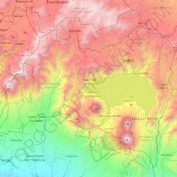
Name: Sololá topographic map, elevation, terrain.
Location: Sololá, Guatemala (14.51437 -91.50665 14.89342 -91.06859)
Average elevation: 1,818 m
Minimum elevation: 230 m
Maximum elevation: 3,516 m
Other topographic maps
Click on a map to view its topography, its elevation and its terrain.
Tacaná
Guatemala > San Marcos > Sibinal
The second route is from the Mexican side, from El Carmen, Talismán bridge, Cacahoatán, and Unión Juárez by vehicle, and from there on foot. This route passes into Guatemala and has been described as one of the most interesting hikes in Central America, leading up winding paths through lush rainforests,…
Average elevation: 3,480 m