
Valdepeñas topographic map
Interactive map
Click on the map to display elevation.
About this map
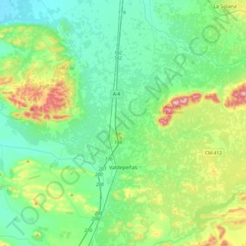
Name: Valdepeñas topographic map, elevation, terrain.
Location: Valdepeñas, Ciudad Real, Kastilien-La Mancha, 13300, Spanien (38.66991 -3.54927 38.94854 -3.24387)
Average elevation: 730 m
Minimum elevation: 645 m
Maximum elevation: 1,004 m
Die Stadt ist zum größten Teil auf Hügeln von wenigen Metern Höhe gebaut. Ihre maximale Höhe erreicht sie in der Sierra del Peral mit 963 M.ü.M. (963 m). Einige andere Berge erreichen eine Höhe von 900 m, besonders in den Bergen in der Nähe von Baños del Peral im Nordosten und in der Sierra de Síles im Nordwesten. Dieses Gebiet im Nordwesten ist von natürlichen Wäldern bedeckt, mit Eichen, Stein-Eichen und Zistrosen.
Other topographic maps
Click on a map to view its topography, its elevation and its terrain.
La Estrella
La Estrella, Toledo, Kastilien-La Mancha, Spanien
Average elevation: 532 m
Cerro Cotoño
Spanien > Kastilien-La Mancha > Albacete > Lezuza
Cerro Cotoño, Lezuza, Albacete, Kastilien-La Mancha, Spanien
Average elevation: 999 m
Herrería
Spanien > Kastilien-La Mancha > Herrería
Herrería, Guadalajara, Kastilien-La Mancha, Spanien
Average elevation: 1,187 m
Los Argüellos
Spanien > Kastilien-La Mancha > Yeste
Los Argüellos, Yeste, Albacete, Kastilien-La Mancha, Spanien
Average elevation: 671 m
Rincón de la Vieja
Rincón de la Vieja, Cuenca, Kastilien-La Mancha, Spanien
Average elevation: 1,132 m
Río Tajo
Río Tajo, Toledo, Kastilien-La Mancha, 28300, Spanien
Average elevation: 622 m