Geolocate

Brighton topographic map

Click on the map to display elevation.

👉 Easily get elevation data in JSON, GeoTIFF and KML formats using Elevation API
Thank you for supporting this site ❤️
Make a donation

Gear up for your next adventure:

As an Amazon Associate, this site earns from qualifying purchases at no extra cost to you.

About this map

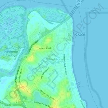
Name: Brighton topographic map, elevation, terrain.

Location: Brighton, City of Brisbane, Queensland, Australia (-27.31387 153.04367 -27.27867 153.07064)

Average elevation: 4 m

Minimum elevation: -1 m

Maximum elevation: 22 m

Queensland trails, hiking, mountain biking, running and outdoor activities

Other topographic maps

Click on a map to view its topography, its elevation and its terrain.

Enoggera Hill

Australia > Queensland > City of Brisbane

Average elevation: 114 m

Blunder Creek

Australia > Queensland > City of Brisbane

Average elevation: 26 m

Tangalooma

Australia > Queensland > City of Brisbane

Average elevation: 41 m

Tangalooma

Australia > Queensland > City of Brisbane

Average elevation: 41 m

Gear up for your next adventure:

🧭Military Style Lensatic Compass - Durable sighting compasses for advanced land navigation and surveying
🧥Packable Rain Jackets - Breathable waterproof layers for unpredictable mountain weather
🎒Daypacks - Compact backpacks for short hikes
🎒Hiking Backpacks - Backpacks designed for hiking and trekking
🧢Wide Brim Sun Hats - Maximum coverage for the face and neck while out in the open

As an Amazon Associate, this site earns from qualifying purchases at no extra cost to you.