Geolocate

Montagnes topographic map

Click on the map to display elevation.

About this map

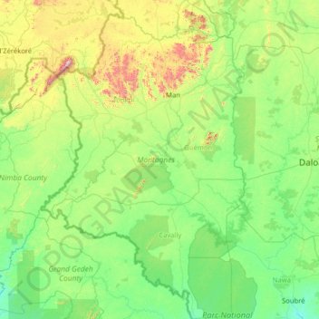
Name: Montagnes topographic map, elevation, terrain.

Location: Montagnes, Côte d'Ivoire (5.63921 -8.60147 8.15698 -6.97149)

Average elevation: 304 m

Minimum elevation: 86 m

Maximum elevation: 1,622 m

Other topographic maps

Click on a map to view its topography, its elevation and its terrain.

Batché Yedé

Côte d'Ivoire > Lagunes

Average elevation: 61 m

Yamoussoukro

Côte d'Ivoire > Yamoussoukro

Average elevation: 196 m

Gear up for your next adventure:

🥤Hydration Packs - Hydration systems for hiking
📍Handheld GPS - GPS devices for hiking and navigation
🩹First Aid Kits - Emergency kits for hiking
🩹Blister Prevention Tape - Apply to friction points before they become painful sores
🛌Sleeping Bags - Sleeping bags for outdoor camping

As an Amazon Associate, this site earns from qualifying purchases at no extra cost to you.