Geolocate

Loen topographic map

Click on the map to display elevation.

About this map

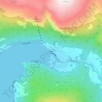
Name: Loen topographic map, elevation, terrain.

Location: Loen, Stryn, Vestland, 6789, Norway (61.85209 6.82665 61.89209 6.86665)

Average elevation: 381 m

Minimum elevation: 0 m

Maximum elevation: 1,357 m

Other topographic maps

Click on a map to view its topography, its elevation and its terrain.

Gloppen

Norway > Vestland

Average elevation: 606 m

Stord

Norway > Vestland

Average elevation: 95 m

Sogndal

Norway > Vestland

Average elevation: 725 m

Fitjar

Norway > Vestland

Average elevation: 92 m

Gear up for your next adventure:

🧼Clip-on Hand Sanitizer - Maintain hygiene when water for washing is scarce
🧼Biodegradable Outdoor Soap - Clean gear and yourself without harming the local ecosystem
🕯️Emergency Whistles - Safety whistles for hiking
🎒Tactical Waist Packs - Quick access to your compass, phone, and snacks while walking
🧭Military Style Lensatic Compass - Durable sighting compasses for advanced land navigation and surveying

As an Amazon Associate, this site earns from qualifying purchases at no extra cost to you.