Geolocate

Fitjar topographic map

Interactive map

Click on the map to display elevation.

About this map

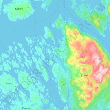
Name: Fitjar topographic map, elevation, terrain.

Location: Fitjar, Vestland, 5419, Norway (59.80770 5.07847 59.99904 5.49928)

Average elevation: 92 m

Minimum elevation: -2 m

Maximum elevation: 730 m

Other topographic maps

Click on a map to view its topography, its elevation and its terrain.

Kaupanger

Norway > Vestland

Average elevation: 249 m

Røldal

Norway > Vestland

Average elevation: 738 m

Frekhaug

Norway > Vestland

Average elevation: 44 m

Meland

Norway > Vestland

Average elevation: 185 m

Loen

Norway > Vestland

Average elevation: 381 m

Myrkdalen

Norway > Vestland

Average elevation: 575 m

Osterøy

Norway > Vestland

Average elevation: 262 m

Vikaneset

Norway > Vestland

Average elevation: 129 m

Lofthus

Norway > Vestland

Average elevation: 247 m

Sognefjorden

Norway > Vestland

Average elevation: 0 m

Florø

Norway > Vestland > Florø

Average elevation: 13 m