Geolocate

Røldal topographic map

Click on the map to display elevation.

About this map

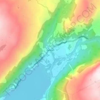
Name: Røldal topographic map, elevation, terrain.

Location: Røldal, Ullensvang, Vestland, 5760, Norway (59.81338 6.79520 59.85338 6.83520)

Average elevation: 738 m

Minimum elevation: 368 m

Maximum elevation: 1,283 m

Other topographic maps

Click on a map to view its topography, its elevation and its terrain.

Stord

Norway > Vestland

Average elevation: 95 m

Gloppen

Norway > Vestland

Average elevation: 606 m

Sogndal

Norway > Vestland

Average elevation: 725 m

Fitjar

Norway > Vestland

Average elevation: 92 m

Gear up for your next adventure:

🥾Hiking Gaiters - Leg protection for trails
🔑Heavy Duty Carabiners - Secure gear to the outside of your pack for easy access
🔪Multitools - Compact tools for outdoor use
🚴Bike GPS - GPS devices for cycling
🧥Packable Rain Jackets - Breathable waterproof layers for unpredictable mountain weather

As an Amazon Associate, this site earns from qualifying purchases at no extra cost to you.