
Arraba topographic map
Click on the map to display elevation.
About this map
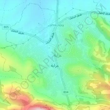
Name: Arraba topographic map, elevation, terrain.
Location: Arraba, Acre Subdistrict, North District, Israel (32.84063 35.32534 32.86171 35.34934)
Average elevation: 257 m
Minimum elevation: 181 m
Maximum elevation: 461 m
Other topographic maps
Click on a map to view its topography, its elevation and its terrain.
Golan Heights
The plateau that Israel controls is part of a larger area of volcanic basalt fields stretching north and east that were created in the series of volcanic eruptions that began recently in geological terms, almost 4 million years ago. The rock forming the mountainous area in the northern Golan Heights,…
Average elevation: 524 m
Sea of Galilee
The Sea of Galilee (Hebrew: יָם כִּנֶּרֶת, Judeo-Aramaic: יַמּא דטבריא, גִּנֵּיסַר, Arabic: بحيرة طبريا), also called Lake Tiberias or Kinneret, is a freshwater lake in Israel. It is the lowest freshwater lake on Earth and the second-lowest lake in the world (after…
Average elevation: -67 m
Mate Asher Regional Council
Israel > North District > Mate Asher Regional Council
Average elevation: 185 m