
Sines topographic map
Interactive map
Click on the map to display elevation.
About this map
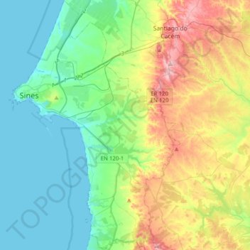
Name: Sines topographic map, elevation, terrain.
Location: Sines, Setúbal, Portugal (37.80495 -8.89392 38.04929 -8.68144)
Average elevation: 85 m
Minimum elevation: 0 m
Maximum elevation: 291 m
Other topographic maps
Click on a map to view its topography, its elevation and its terrain.
Praia da Costa de Santo André
Portugal > Setúbal > Vila Nova de Santo André
Praia da Costa de Santo André, Vila Nova de Santo André, Santo André, Santiago do Cacém, Setúbal, Portugal
Average elevation: 7 m