
Seixal topographic map
Interactive map
Click on the map to display elevation.
About this map
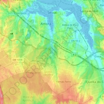
Name: Seixal topographic map, elevation, terrain.
Location: Seixal, Setúbal, Portugal (38.54068 -9.17835 38.65588 -9.04776)
Average elevation: 38 m
Minimum elevation: -3 m
Maximum elevation: 105 m
Other topographic maps
Click on a map to view its topography, its elevation and its terrain.
Praia da Costa de Santo André
Portugal > Setúbal > Vila Nova de Santo André
Praia da Costa de Santo André, Vila Nova de Santo André, Santo André, Santiago do Cacém, Setúbal, Portugal
Average elevation: 7 m