
Anlier topographic map
Interactive map
Click on the map to display elevation.
About this map
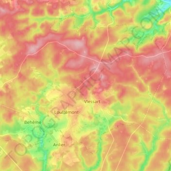
Name: Anlier topographic map, elevation, terrain.
Location: Anlier, Léglise, Neufchâteau, Luxemburg, Wallonië, België (49.76752 5.57236 49.83728 5.70534)
Average elevation: 459 m
Minimum elevation: 371 m
Maximum elevation: 521 m
Other topographic maps
Click on a map to view its topography, its elevation and its terrain.
Xaimont
België > Luxemburg > Neufchâteau > Léglise
Xaimont, Léglise, Neufchâteau, Luxemburg, Wallonië, 6860, België
Average elevation: 430 m